Subject: Colonial Upper Midwestern United States
Period: 1756 (circa)
Publication:
Color: Hand Color
Size:
18.7 x 25.7 inches
47.5 x 65.3 cm
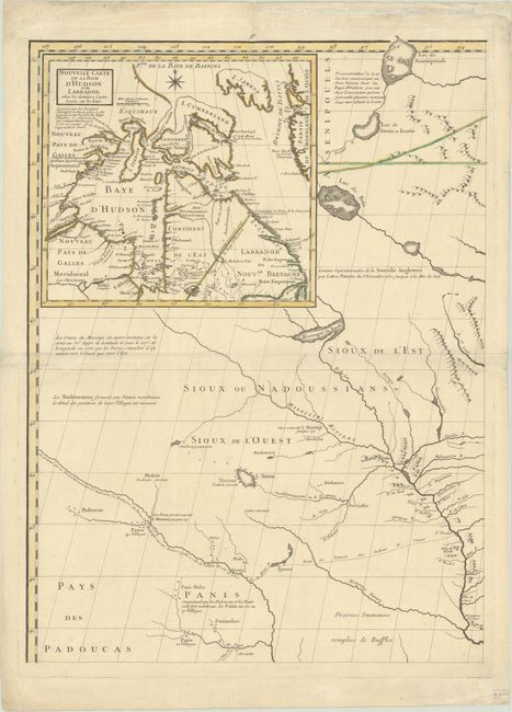
This is the upper left sheet from a French edition of John Mitchell's monumental map of eastern North America published by George Le Rouge. The complete map is considered by many to be the most important map of America ever produced. It was so widely regarded that it was used as the source document to determine the new boundaries of the United States at the Treaty of Paris in 1783. The map continued to be used for nearly all boundary disputes between Canada and the United States in the 19th century.
This sheet shows the area of today's Iowa and Minnesota, with parts of Illinois, Wisconsin, Nebraska, Kansas and Dakota. The overall level of detail provided is unlike any preceding map and includes copious useful notations describing the land, rivers, Indian tribes, and earlier explorations. Topography and hydrology is well represented, as are the numerous Indian villages, forts, and trading paths. A note along the left border of the map indicates that the sources of the rivers and the country beyond this map are not well known. Another notation along the Missouri River indicates that it flows to the west a distance equal to that of the Ohio River flowing east, demonstrating a common belief at the time of symmetrical geography. An inset at top left ("Nouvelle Carte de la Baye d'Hudson et de Labrador…") depicts the region around Hudson Bay and includes a note stating that a northwest passage is unlikely.
Since the publication date is not on this sheet, the circa date of 1756 was used (first French edition), as no known changes were made to this sheet in subsequent states of the map. This is a nice opportunity to own an important piece of this monumental map.
References: cf. Pritchard & Taliafero #33.
Condition: B+
Dark impression with contemporary outline color on thick paper with the watermarks of a Maltese cross encircled in rosary beads and "T Du Moyen Auvergne." The centerfold has been reinforced with archival tissue on verso, and several edge tears and chips have also been archivally repaired, with one tear entering 1" into image at top. There are some tiny ink spots in Hudson Bay and marginal soiling.