Subject: Colonial North America, Asia & Pacific Ocean
Period: 1777 (circa)
Publication: Diderot's Encyclopedia (Supplement)
Color: Black & White
This lot includes the set of 10 maps from the Supplement to Diderot's Encyclopedie, edited by the former Jesuit philosopher and writer Jean-Baptiste-Rene Robinet. Robinet chose Didier Robert de Vaugondy to create maps to illustrate articles by Samuel Engel, a geographer based in Basel. These great maps illustrate many of the cartographic myths of the period, with fascinating views of some of the early cartographic theories concerning the western part of North America.
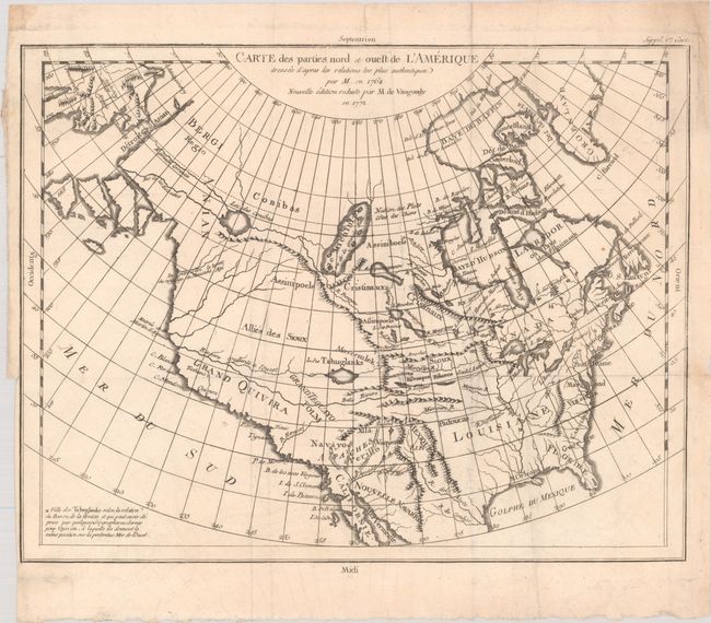
A. Carte des Parties Nord et Ouest de l'Amerique Dressee d'Apres les Relations les Plus Authentiques par M... en 1764, dated 1772 (14.8 x 11.5"). Robert de Vaugondy's rendition of Samuel Engel's map of 1764 alters the North American coastline slightly and extends to include part of Asia. The myth of a Northwest Passage continues to persist, here linking the Detroit d Anian with Lac Michinipi by a system of rivers and a large Lac des Conibas. There is also a River of the West that connects to another large lake, L. des Tahuglanuks that is located near a remnant of Lanhotan's R. Longue. Alaska is shown as a series of large islands. California is labeled Grand Quivira. References: Pedley #453; Portinaro & Knirsch #158.
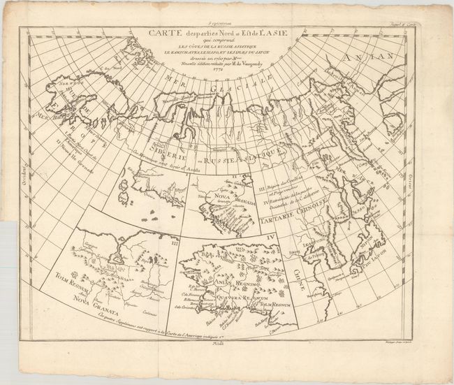
B. Carte des Parties Nord et Est de l'Asie qui Comprend les Cotes de la Russie Asiatique le Kamschatka, le Jesso, et les Isles du Japon..., dated 1772 (14.8 x 11.8"). This unusual map details the northern coastline of Russia (including Scandinavia), the eastern coast of Asia to below Nanking, and a bit of the coast of America called Anian. Inset into the map are four small maps of the western part of North America: I - Features the entire western coast with Japan just a short distance offshore; II - Focuses on Nova Granada showing the Mexican coast of the Gulf of California; III - Focuses on the Zubgara and Tolm Regnum of Nova Granada and the mythical seven cities of Cibola; and IV - Depicts Anian Regnum including Quivira Regnum and another Tolm Regnum. References: Pedley #406; Wagner (NW) #637, pp. 158-162.
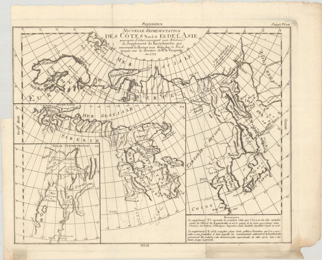
C. Nouvelle Representation des Cotes Nord et Est de l'Asie, pour Servir d'Eclaircissement aux Articles du Supplement de Encyclopedie..., dated 1772 (14.7 x 11.5"). Interesting map of the northeast coast of Asia depicting Kamchatka, Japan, and Korea. It also shows part of what is present-day Alaska. The Tchutski (Chukotskiy) Peninsula stretches very close to the American landmass, hinting at a possible land bridge. Within the larger map are two insets (one within the other). The insets represent an evolving understanding of the geography of Kamachatka, with the map being the latest iteration. The first inset, No. 1, was completed by Abu al-Ghazi Bahadur, who was the ruler of Khiva in present-day Uzbekistan for 20 years. References: Pedley #402.
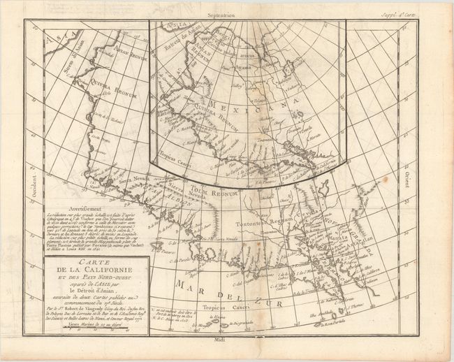
D. Carte de la Californie et des Pays Nord-Ouest Separes de l'Asie par le Detroit d'Anian..., dated 1772 (14.6 x 11.6"). Two contrasting maps, one inset into the other. The inset map is based on a world map by Plancius issued in 1641, while the larger map is based on Visscher's map of 1612. Other than a recognizable Baja California, the maps are filled with the cartographic myths of the 17th century. The northwest coast bulges too far to the west. Both maps feature the seven cities of Cibola gathered around a spurious lake in the American Southwest. References: Wheat (TMW) #159; Wagner (NW) #632; Pedley #473.
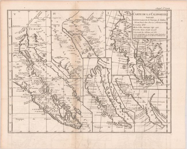
E. Carte de la Californie Suivant I la Carte Manuscrite de l'Amerique de Mathieu Neron Pecci olen Dressee a Florence en 1604..., (15.3 x 11.6"). This sheet has five depictions of California that present a fascinating cartographic history of the region. It was one of ten maps compiled by Robert de Vaugondy for Diderot's important encyclopedia and depicts the mapping of California by five important cartographers. The earliest map reproduces Neron Pecci's manuscript map of 1604 showing the peninsula with a ragged coastline and place names derived from Cabrillo's voyage of 1542-3. The second map is a detail from Sanson's 1656 map showing the island of California with place names from the voyage of Vizcaino. Map three is from Delisle's map of America of 1700 with the question of California's insularity left open to interpretation. Next is Fra. Eusebio Kino's important map of 1705 that finally ended that cartographic myth. It is based on his overland expedition from the mainland to the Sea of Cortez. Finally, map five is a portion of a Spanish map, showing the Jesuit explorations, that first appeared in Miguel Venegas' Noticia de la California in 1757, which is the first published history of California. This is an essential map for any California map collection. References: McLaughlin #241; Fite & Freeman #52; Heckrotte & Sweetkind #15; Pedley #474.
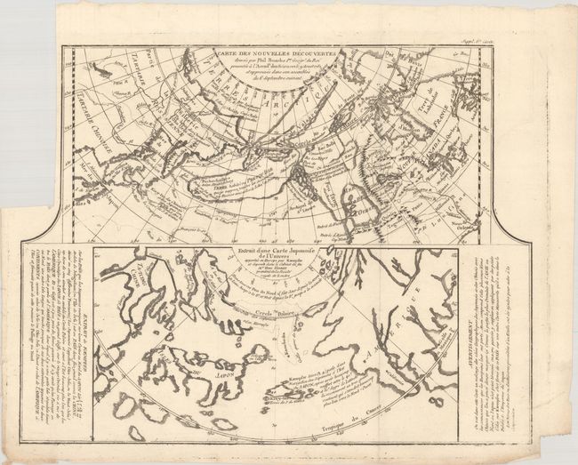
F. Carte des Nouvelles Decouvertes Dressee par Phil. Buache... [on sheet with] Extrait d'une Carte Japonoise de l'Univers..., (14.9 x 11.7"). Two very contrasting maps within a single border. Each map covers the north Pacific, including the continents bordering it. The top map depicts the theories of Philip Buache concerning the Northwest Passage, with numerous possible routes through North America, including Lace de Valasco, Lac de Fonte, and Mer de l'Ouest. Alaska is shown as an elongated island. In Asia, Kamchatka is fairly well formed but Japan is still quite misshapen. The bottom chart depicts the region per Kaempfer, with Japan nicely detailed, but the coasts of both Asia and North America very deformed. References: Falk (AK) #1752-2; Wagner (NW), pp. 158-162; Pedley #452; McGuirk #146; Kershaw #1230.
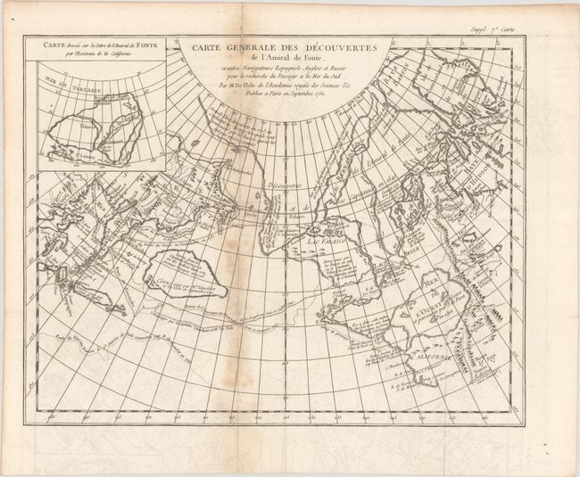
G. Carte Generale des Decouvertes de l'Amiral de Fonte, et Autres Navigateurs Espagnols, Anglois et Russes pour la Recherche du Passage a la Mer du Sud, (15.1 x 11.8"). This is one of the more remarkable combinations of fact and fiction ever published. This map of the North Pacific and Northwest had as its source a 1708 article in the Monthly Miscellany that purported to be a newly discovered account of a voyage in 1640 by the Spanish Admiral, Bartholomew de Fonte. Thereafter, the newly presented information was changed and elaborated upon, notably by this series of maps which appeared in Diderot's Encyclopedia. In its concept, it promoted the hopes of a Northwest Passage and depicts the existence of Mer de l'Ouest or the Sea of the West. The tracks for the Russian exploration in 1741 and other explorers are traced in the Pacific. Inset at upper left is a small map, "Carte dressee Sur la lettre de l'Amiral de Fonte par l'Ecrivain de la Californie" detailing the purported track of Admiral de Fonte.
The title credits Delisle as the source for the map. There was much controversy at the time regarding the veracity of the voyages by de Fonte. In 1750, Joseph-Nicolas Delisle presented a paper and map at the Academy of Sciences in Paris that consolidated the vast amount of geographical information he had acquired in Russia. The paper caused a sensation, but the map, drawn by Philippe Buache and designed to show the "coherence of Russian discoveries with those of de la Fuente" (de Fonte), was met with skepticism. Delisle hired Bellin to re-work the map, presenting it to the Academy in 1752. That same year an annoyed Buache drew his own map and presented it along with a paper to the Academy. The controversy was further enflamed by Robert de Vaugondy's own presentation to the Academy the following year when he expressed his doubts about the truth of de Fonte’s voyages and criticized the maps illustrating it. See Pedley pages 74-78 for more on the politics and personalities in this fascinating story. References: Hayes pp. 26-27; Pedley #454.
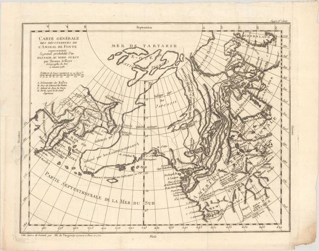
H. Carte Generale des Decouvertes de l'Amiral de Fonte Representant la Grand Probabilite d'un Passage au Nord Ouest, dated 1772 (14.6 x 11.4"). This is probably the most extravagant of all the Northwest Passage maps based on the Jefferys model. Thomas Jefferys was an ardent believer in the northern route to Asia through a passage described by Juan de Fuca in 1592 and in the fictitious story of Bartholomew de Fonte's discoveries in 1640. Alaska is shown in an early, peninsular form based on the map of Mueller. References: cf. Hayes. pp. 26-27; Pedley #455 and pp. 74-78; Wagner (NW) #637.
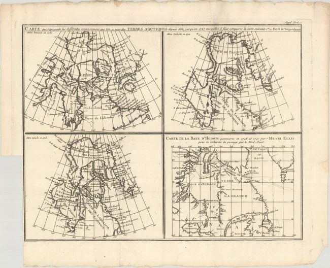
I. Carte qui Represente les Differentes Connoissances que l'on a eues des Terres Arctiques Depuis 1650 Jusqu'en 1747..., dated 1773 (14.9 x 11.6"). This is the second state of a fascinating group of four maps on one sheet illustrate the cartography of Sanson in 1750, Delisle in 1700 and 1703 and that of the famous Arctic explorer Henry Ellis in his quest for a Northwest Passage via Hudson Bay in 1746-47. All of the maps depict the Hudson and Baffin Bay region, showing the development of the region's cartography between 1650 and 1747. References: Kershaw #477; Pedley #24.
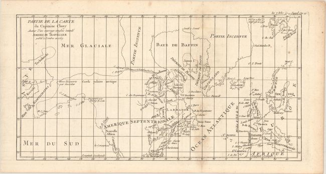
J. Partie de la Carte du Capitaine Cluny Auteur d'un Ouvrage Anglois Intitule American Traveller Publie a Londres en 1769, (16.5 x 8.7"). While this fascinating map covers the Arctic from Asia through Europe, the focus of the map is on the North American Arctic region. The most important feature of the map is the early depiction of what is present-day Alaska, patterned after Muller's epic map of 1750 that was the first to show the Russian discoveries, also noted here. The peninsula is shown as an indistinct dashed line that extends out to M. S. Jean. Early explorations are noted: "Terre decouverte par Gwosdew (Gwosden)" and "Decouvert par Bering en 1741." A very interesting Northwest Passage is shown from Repulse Bay in the north part of Hudson Bay into the Arctic Ocean at Cape Fowler. The River of the West enters at about 45° with an uncertain course that is roughly aligned with the F. York river in the southwest of Hudson Bay, another allusion to the Northwest Passage. References: Pedley #460; Wagner #637-10.
References: Warren (Portolan - Spring 2002) pp. 32-47.
Condition:
The maps are in A or B+ condition. All were issued folding, and the majority have binding trims in the blank margin. Condition issues include minor to light offsetting, light toning along some of the folds, and a few maps with short wormtracks that have been infilled with archival materials on verso.