Subject: Western Hemisphere - America
Period: 1787 (circa)
Publication: Atlas Universel
Color: Hand Color
Size:
15.6 x 11.1 inches
39.6 x 28.2 cm
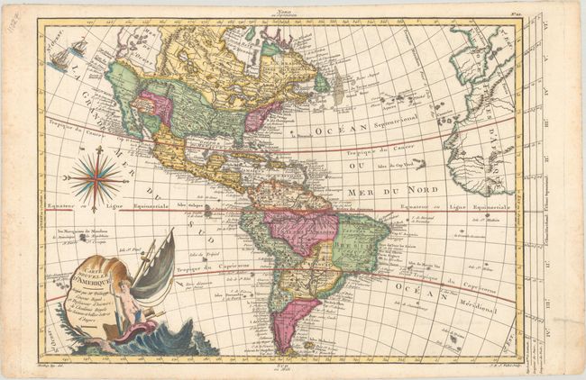
This charming map of the Americas has very nice detail for a relatively small map, showing cities, rivers, Indian tribes, lakes, anchorages, and more. In North America there is a huge Sea of the West with its northern shore conveniently hidden by the border -- alluding to a possible Northwest Passage. Directly to the south of the Sea of the West is the mythical Quivira, and farther south, Teguaio. The area that would become Texas is labeled as Cenis ou Tecas, and in the north the Great Lakes are erroneously depicted as interconnected. In South America the Amazon River is boldly depicted with its headwaters in Peru. Two sailing ships, a stunning compass rose, and a nautical title cartouche complete the composition. Drawn by Moithey and engraved by J. E. J. Vallet. This is the third state as described by McGuirk, with "No. 112" in the upper right margin.
References: McGuirk #136.
Condition: A
A crisp impression with an archivally repaired edge tear and light foxing, all confined to the blank margins.