Subject: Mobile Bay, Alabama
Period: 1763 (circa)
Publication:
Color: Hand Color
Size:
5.6 x 10.8 inches
14.2 x 27.4 cm
Thomas Jefferys was one of the most important English map publishers of the 18th century. His work included prints and maps of locations around the world, but his most notable maps are of North America and the West Indies. He began his career in the map trade in the early 1730s, working as an engraver for a variety of London publishers, and eventually setting up his own shop. In 1746, he was appointed Geographer to the Prince of Wales, and in 1760 he became Geographer to the King. These titles granted access to manuscripts and cartographic information held by the government. In the early 1760s he embarked on an ambitious project to produce a series of English county maps based on new surveys, but ran out of money and filed for bankruptcy in 1766. He then partnered with London publisher Robert Sayer, who reissued many of Jefferys plates and continued to issue new editions after Jefferys' death in 1771. Jefferys' American Atlas and the accompanying West-India Atlas, published post posthumously, are considered his most important cartographic works.
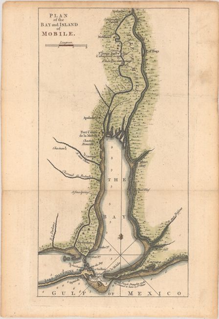
This small folding map of Mobile Bay was issued in William Roberts' An Account of the First Discovery, and Natural History of Florida. It was published shortly after the Treaty of Paris and intended to inform British readers of their newly acquired lands. The map extends from the entrance to Mobile Bay north to Fort Conde (later Fort Charlotte) and Apalaches, including a handful of place names, soundings in the water, two lighthouses, and notation "The best Entrance into the Bay." While the map has no attribution, Roberts' volume was published by Thomas Jefferys. A note in Sabin states that the Plan of Mobile Bay accompanied a letter on Florida by Captain Thomas Robinson.
References: Howes #R-348; Sabin #71926.
Condition: A
Issued folding on watermarked paper with light toning and minor soiling in the margins.