Catalog Archive
Auction 190, Lot 165

"[Lot of 2] A Correct Map of the Georgia Western Territory [and] Map of the Country Embracing the Various Routes Surveyed for the Western & Atlantic Rail Road of Georgia",

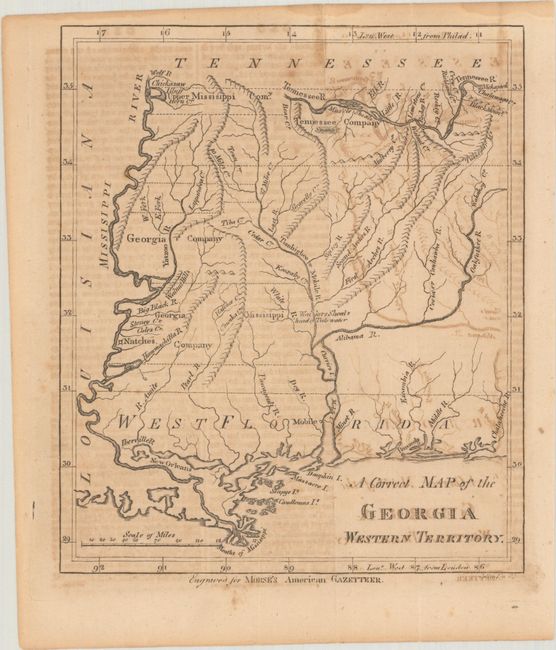
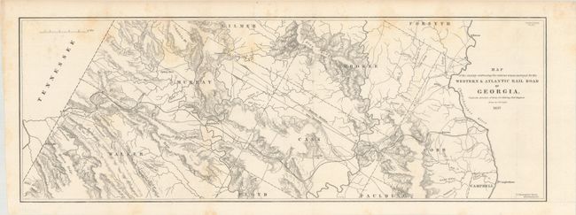
Subject: Southern United States, Georgia

Period: 1797-1837 (circa)

Publication:

Color: Black & White

Size:
See Description
Download High Resolution Image
(or just click on image to launch the Zoom viewer)

A. A Correct Map of the Georgia Western Territory, by (Rev.) Jedidiah Morse, from Morse's American Gazetteer, circa 1797 (6.1 x 7.1"). An interesting and historical map that covers the region that would become Mississippi and Alabama. There is good information on watersheds, and some topography is shown. Many rivers are named, but only four towns: New Orleans, Natches, Mobile, and Pensacola. Along the Mississippi River are lands of the Upper Mississippi Company and the Georgia Company, and to the east is the Tennessee Company. These lands were a part of the infamous Yazoo Land Fraud. In 1795 the governor of Georgia, George Mathews, signed a bill that agreed to sell almost 40 million acres to speculators in the Yazoo Land Act. This corrupt land deal led to the downfall of many popular politicians. President George Washington, speaking about Yazoo said, "These acts embrace an object of such magnitude and in their consequences may so deeply affect the peace and welfare of the United States..." Read more about this early scandal here. Accompanied by a 10-page section of Morse's Gazetteer covering Georgia Western Territory. Condition: Issued folding with offsetting. (B)

B. Map of the Country Embracing the Various Routes Surveyed for the Western & Atlantic Rail Road of Georgia, by U.S. Government, from Sen. Doc. No. 57, 25th Congress, 2nd Session, dated 1837 (21.4 x 7.6"). According to Modelski this is the earliest printed railroad map residing in the collection of the Library of Congress that was based on government surveys. The map was surveyed and drawn by M. M. Stansbury of the U. S. Topological Bureau. When the route was completed in 1850, it ran 138 miles between today's Atlanta (then called Terminus) and Chattanooga. Its strategic location made it a key supply route for the Confederacy and was the track for the famous 'Andrew's Raid' in 1862 when Union soldiers captured the locomotive General. A most desirable and early railroad map. References: Modelski Railroads First 100 Years No. 6 (illustrated); Modelski #613; Claussen & Friis # 181. Condition: Issued folding with light scattered foxing at top. (B+)

References:

Condition:

See description above.

Estimate: $300 - $375

Sold for: $220

Closed on 11/16/2022

Archived