Subject: Mozambique
Period: 1700 (circa)
Publication: Neptune Francois
Color: Hand Color
Size:
32.1 x 22.3 inches
81.5 x 56.6 cm
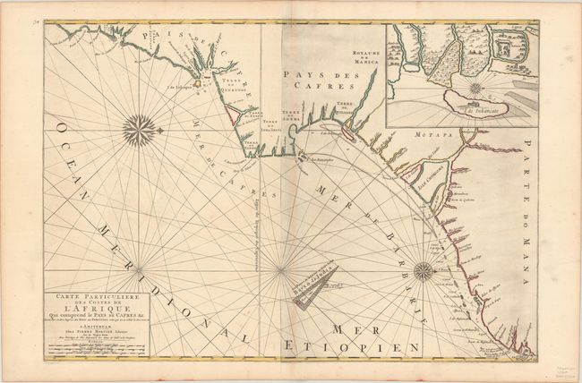
This boldly engraved sea chart traces the coast of Mozambique from the town of Mozambique to south of Maputo Bay. There is little information inland, but small coastal islands, settlements, bays, and the mouths of rivers are identified along the coast. An inset at top right depicts a plan view of Sofala and the island of Inhancato. Founded by Swahili merchants during the medieval era, Sofala was one of the oldest harbors in Southern Africa and was once the primary port for the Kingdom of Mwenemutap. The once-thriving city was superseded by modern Beira in the late 19th century and has since been largely lost to the rising sea. The chart is crisscrossed with rhumblines, and two ornate compass roses orient the north to the right. Three distance scales appear in the title cartouche. A large and very striking chart printed on two joined sheets.
References: Norwich #263.
Condition: B+
A sharp impression with contemporary color on sturdy paper. There is light soiling, minor foxing and offsetting, and a hint of toning along the joint.