Subject: Texas
Period: 1861-73 (circa)
Publication:
Color: Hand Color
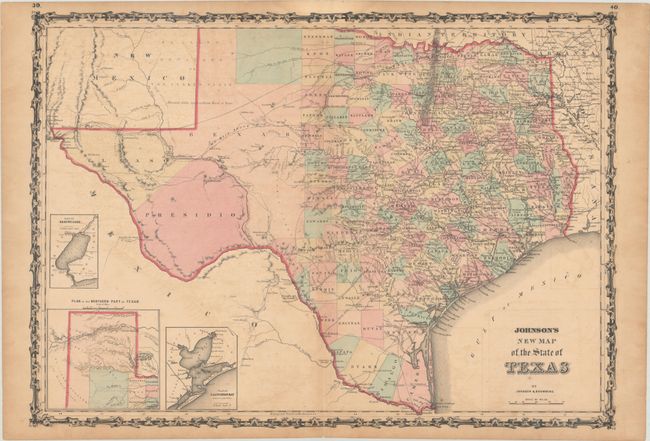
A. Johnson's New Map of the States of Texas, by Johnson & Browning, from Illustrated Family Atlas of the World, published 1861 (24.0 x 17.0"). The first edition of this handsome map, with county development mostly in eastern Texas and only the three large counties of El Paso, Presidio, and Bexar in the west. The panhandle, noted as the Staked Plain (Elevated Table Land, without Wood or Water), includes a large section that is unorganized. There are numerous wagon roads, a few completed railroads, and the US Mail Route traced on the chart. Insets include a Plan of Sabine Lake, Plan of the Northern part of Texas, and Plan of Galveston Bay. Surrounded by Johnson's early strapwork border. Blank on verso. Condition: Lightly toned with some minor offsetting and a centerfold separation that just enters the border at bottom. (B)
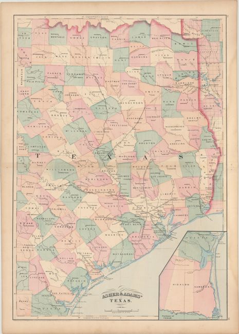
B. Asher & Adams' Texas, by Asher & Adams, dated 1871 (15.9 x 22.5"). A county map of East Texas extending from Louisiana west to beyond San Antonio. Depicts numerous railroads radiating from Houston, two spurs of the Texas Pacific Railroad, one from Shreveport to Longview, another from Texarcana to Clarksville, plus the Gulf Western Texas Railroad from Indianola to Victoria. The large inset "Portions of Texas" shows the region between Corpus Christi and Brownsville in more detail. Condition: There is a light dampstain along the right sheet edge that just enters the image. (B+)
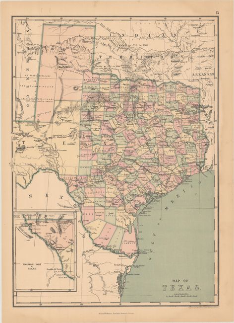
C. Map of Texas, by J. David Williams, circa 1873 (12.5 x 17.3"). This is an interesting map of Texas that uses longitudinal projection lines, which increase in width the further south one goes, to more accurately reflect the curvature of the earth and distance between degrees of longitude. It features superb detail of trails, ponds, springs, forts, and railroads and is filled with information on the region's resources (gypsum, salt, arable land, timber, sand, course grass, and forests labeled Mesquite Openings). The "Western Part of Texas" is shown in an inset on the same scale as the main map. Printed by Ferd. Mayer and son in both New York and Paris, and published in Williams' People's Pictorial Atlas Condition: There is a light dampstain along the right sheet edge that just enters the image in a few spots. (B+)
References:
Condition:
See description above.