Subject: Boston, Massachusetts
Period: 1879-1920 (circa)
Publication:
Color: Printed Color
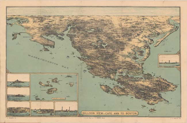
A. Balloon View - Cape Ann to Boston, by F.K. Rogers, dated 1879 (18.0 x11.3"). This scarce "balloon view" extends from the North Shore to Salem and Boston, and folds into wrappers (4.2 x 6.5") that carry the same title. It is augmented by six inset views including a large Isles of Shoals (Maine/New Hampshire). Numerous railroads are depicted in the region and tiny ships fill the Massachusetts Bay in the foreground. Drawn by F.K. Rogers. Imprint below neatline "Copyright 1879, by J.H. Daniels, Boston" with his address given on the cover as 223 Washington Street. Blank verso. A scarce issue with only a couple examples located in institutions. Condition: The map has faint offsetting with a few edge tears and tiny fold separations that have been closed on verso with archival tape. The wrappers have been repaired with archival tape. (B+)
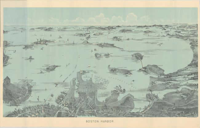
B. Boston Harbor, by Walker Lithography, circa 1897 (21.4 x 12.1"). This folding bird's-eye view of the region was produced for the tourist trade. The map extends from the coastal area of East and South Boston across the water to the main ship channel and the Boston Light. It locates Winthrop, Thompson's Island, Moon Island, Deer Island, Nahant, Green Island, the Brewster Islands, Strawberry Hill, Fort Warren, Hough's Neck and much more. The Fore River Ship & Engine Co. is on the distant horizon. Steamer routes to Nantasket Beach, Nahant, Winthrop and more are identified. Folds into paper covers entitled "Bird's-Eye View Map of Boston Harbor." Walker's maps were often sold as advertising maps under another name, most notably by the Union News Co. Condition: Clean, bright, and near fine. (A)
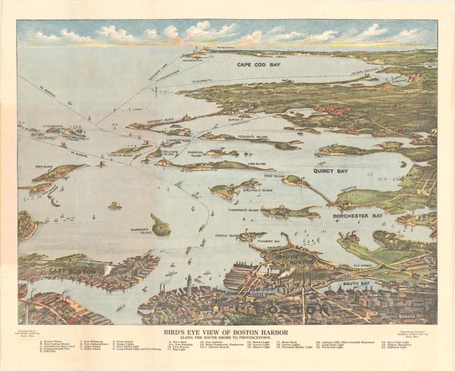
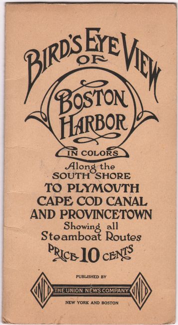
C. Bird's Eye View of Boston Harbor Along the South Shore to Provincetown, by the Union News Co., dated 1920 (19.2 x 14.0"). This attractive bird's-eye view folds into paper covers with the title "Bird's Eye View of Boston Harbor in Colors Along the South Shore to Plymouth Cape Cod Canal and Provincetown Showing all Steamboat Routes. Price 10 cents." The map extends from South Bay all the way to Cape Cod Bay and Provincetown. At the bottom is a numerical key naming and locating 25 landmarks and lighthouses. The map names East Boston, Dorchester Bay, Quincy Bay, Governor's Island, Peddock's Island, Deer Island, Nantasket Beach, Duxbury, Jerusalem, and much more. Several ferry and ship routes are shown. The map was printed by either the collotype or color gravure method by the Federal Engraving Co., Boston. An uncommon issue that was published by The Union News Company. Condition: The map is fine with minor wear to wrappers. (A+)
References:
Condition:
Issued folding. See description above.