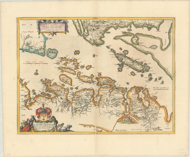
Subject: Southwestern Scotland
Period: 1654 (published)
Publication: Theatrum Orbis Terrarum, sive Atlas Novus...
Color: Hand Color
Size:
20.8 x 15.4 inches
52.8 x 39.1 cm
This crisply engraved map shows the Firth of Lorne, along with the islands and portions of Jura and Mull. It is based on the cartography of Timothy Pont, who surveyed Scotland in the 1580s and 1590s. The decorative cartouches are surrounded by sheep representing the agrarian nature of this region. Blaeu dedicates the map to Sir James Balfour, 1st Baronet of Denmilne and Kinnaid, an annalist and antiquarian, in the cartouche at bottom left, which also features Balfour's coat of arms. The map is oriented with the north to the right. Latin text on verso.
Publication of Bleau’s atlas of Scotland and Ireland (Atlas Novus, Volume V) in 1654 was a landmark publication in cartographic history. Most of the maps were based on the surveys of Timothy Pont, which had been done half a century earlier. The work took over seven decades to bring to publication; it was delayed by wars, copyright restrictions, and intermittent official support. These maps formed the basis for the cartography of Scotland for the next one hundred years. Today, the maps are scarce due to the relatively short publication history of the atlas.
References: Van der Krogt (Vol. II) #5880:2.
Condition: B+
A sharp impression with minor toning along the centerfold and an archival repair to a centerfold separation that extends approximately 1.5" into the image at bottom.