Subject: Irish Sea
Period: 1693 (circa)
Publication: Great-Britain's Coasting Pilot
Color: Hand Color
Size:
22.9 x 18 inches
58.2 x 45.7 cm
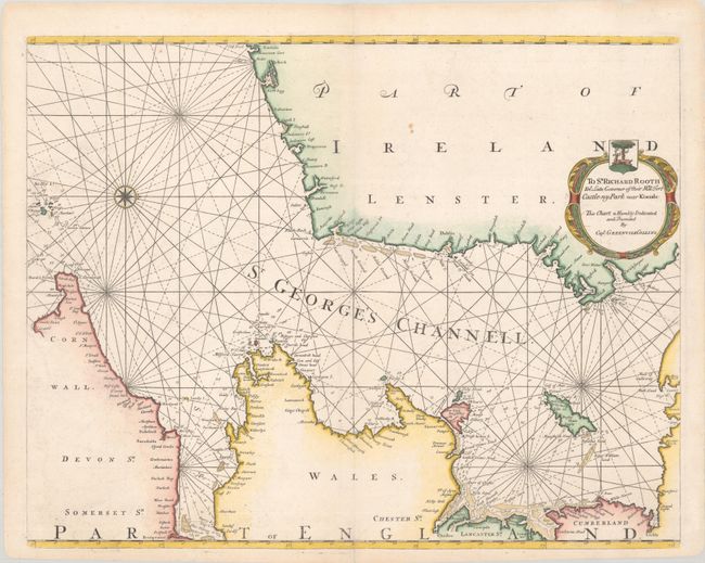
This exquisite chart of St. George's Channel includes stretches of the Irish, English, and Welsh coastlines, Anglesey, and the Isle of Man. Place names line the coasts, among them Dublin, Swansea, and Liverpool, but the majority of the information on the map is confined to the sea. The Channel is crisscrossed by rhumb lines and features plenty of depth soundings and hazards. A compass rose capped with fleur-de-lis orients the north to the right. The decorative cartouche at right dedicates the chart to Sir Richard Rooth, the governor of James's Fort on Kinsale harbor. This fort was occupied by Jacobite forces during the Williamite War, which ended just a couple years before the publication of this chart.
In 1681 Capt. Greenville Collins (fl.1669-1694) an officer in the Royal Navy was appointed by the Admiralty to make a complete survey of the coasts of Great Britain. Prior to this date the charts used by English mariners were copies of Dutch charts that had many inaccuracies. The task of surveying the entire coasts was formidable and took about 7 years, at the end of which only 46 surveys were finally used in an atlas titled "Great Britain's Coasting-Pilot Being a New and Exact Survey of the Sea-Coast of England," which was first published in 1693.
References: Shirley (BL Atlases) M.COLL-1a #13; Verner (MCC-58) #45.
Condition: A
A crisp impression on a bright sheet with a couple small spots and a hint of offsetting. Short centerfold separations at top and bottom have been repaired on verso with archival materials.