Subject: World, World War II
Period: 1941 (dated)
Publication:
Color: Printed Color
Size:
28.9 x 21.1 inches
73.4 x 53.6 cm
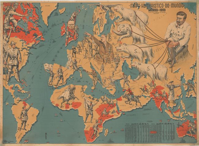
This superb persuasive map was created by Antonio Soares, a Portuguese painter and caricaturist. Despite the map extending to show most of the world, the focus is on Europe, with each country outlined and represented by a soldier. Three key political figures are also included: Hitler in Germany, Stalin in the Soviet Union, and Churchill in Britain. Countries that have fallen to the Nazis are marked with a swastika, and countries under Soviet rule are marked with a hammer and sickle. Stalin sits comfortably with a pipe in his mouth, holding ropes tied to four polar bears that attack surrounding countries. Hitler appears confident, saluting his soldiers who run into battle. The only countries not represented by soldiers are Switzerland, which is a white dove of peace, and Finland, which is a vulture with bloody claws hovering over Norway and Sweden. Three soldiers hold up flags: a kneeling soldier in southern France hoists a tattered flag that reads "France can't die;" in contrast, an optimistic Portuguese soldier waves a flag that reads "country of peace and work." A soldier in central Africa carries a flag that reads "Free France." In the Americas, the Statue of Liberty stands tall in the United States holding a scroll that reads: "Free people can never be defeated," while the soldier in South America raises his arm in a Nazi salute towards Hitler. At bottom right is a table listing the military resources available to each country, such as troops, aircraft, ships, cannons, and tanks. Britain and its colonies are marked in red both in the table and on the map.
Published by Livraria Popular in Lisbon, and "endorsed by the censorship commission" (as noted below the title). This map is very rare - we were only able to find a few examples held in institutions, and none offered in the marketplace in the last 30 years.
References:
Condition: B+
Bold color with light soiling, toning and foxing. There are chips in the corners of the sheet that have been professionally repaired, with a small amount of the image (mostly the neatline) and coloring replaced in facsimile. The map has been professionally backed in thin, archival tissue.