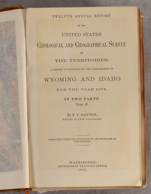
Subject: Yellowstone, Wyoming, Idaho & Utah
Period: 1883 (published)
Publication:
Color: Printed Color
Size:
5.9 x 9.4 inches
15 x 23.9 cm
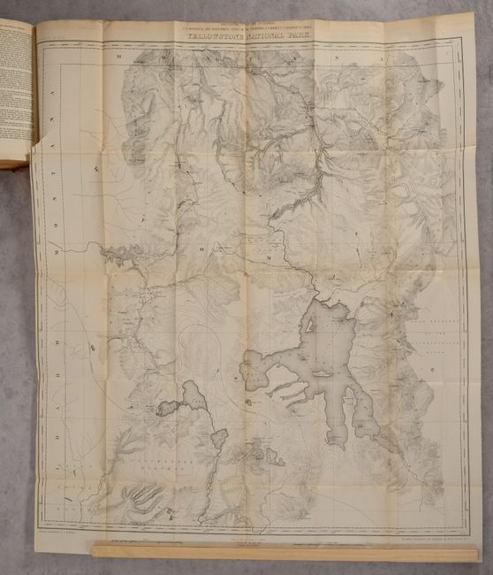
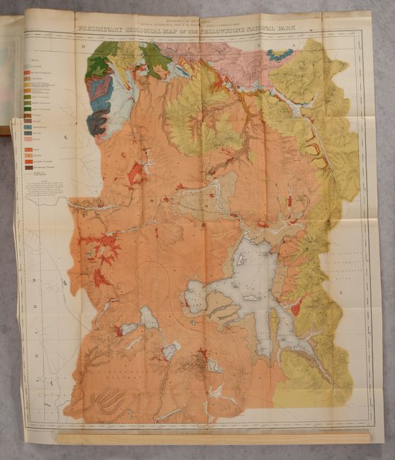
This the second volume of the twelfth and final report of Hayden's survey of the West, focusing specifically on Yellowstone. It includes Yellowstone National Park (28.3 x 31.9"), which Wheat describes as one of "the first modern maps of the Park." It shows the entire park from the Montana state line south to well beyond Yellowstone, Shoshone, Lewis, and Heart lakes, and from the border with Idaho east to the Yellowstone Range and the east fork of the Yellowstone River. There is terrific detail of topography with contour intervals at 100 feet, watershed, and numerous features, all at a scale of 1 inch = 2 miles. The map names the Upper, Shoshone, Gibbon, and Heart Lake geyser basins, Mud Geysers, Mammoth Hot Springs, and much more. Primary triangulation by A.D. Wilson and secondary triangulation and topography by Henry Gannett.
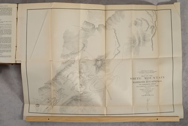
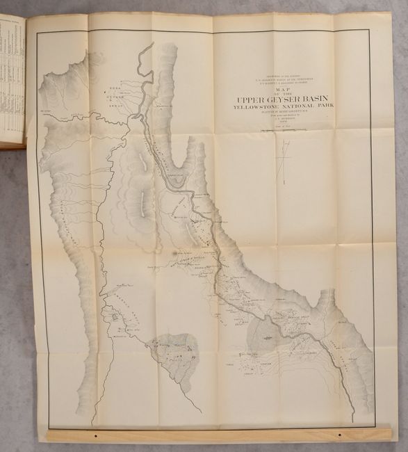
The report itself includes 11 other maps, including Map of the White Mountain or Mammoth Hot Springs on Gardiners River Yellowstone National Park (23.9 x 17.0") and Map of the Egeria Springs Firehole River between the Upper and Lower Geyser Basins (17.0 x 23.9"). The first map presents good detail of the Mammoth Hot Springs region of Yellowstone National Park and locates the Main Springs, Sulphur Spring, Cleopatra Spring, and bath houses. It shows a planned road just to the west of Lookout Hill, and the Gardiner River is delineated farther to the east. The second map depicts the Midway Geyser Basin in Yellowstone National Park, which contains two of the largest hot springs in the world. The "Grand Prismatic Spring" is shown at the center of a web of connected creeks emptying into the Firehouse River. To the south, near the bend in the river, is an unnamed "Geyser" (Excelsior Geyser), which at the time could erupt up to 300 feet high and has since become a hot spring. Rudyard Kipling, who visited Yellowstone in 1889, immortalized this basin by referring to it as "Hell's Half Acre." Plotted by Henry Gannett under the direction of F.V. Hayden, Geologist in Charge.
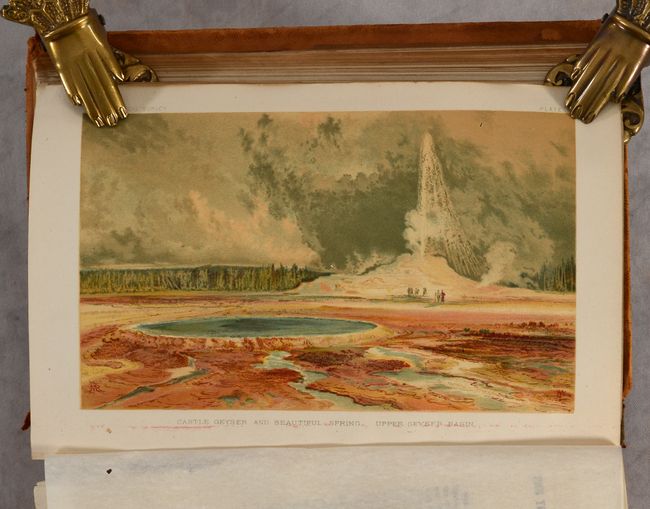
The volume contains the geological reports of W. H. Holmes, the thermo-hydrological reports of A.C. Peale, and the topographic reports of Henry Gannett. There are 117 black and white and sepia tinted figures and plates illustrating their findings. Unusual for a report of this era, there are 4 striking chromolithographs showing Mammoth Hot Springs, the Grand Canon of the Yellowstone River, Castle Geyser, and Great Blue Spring.
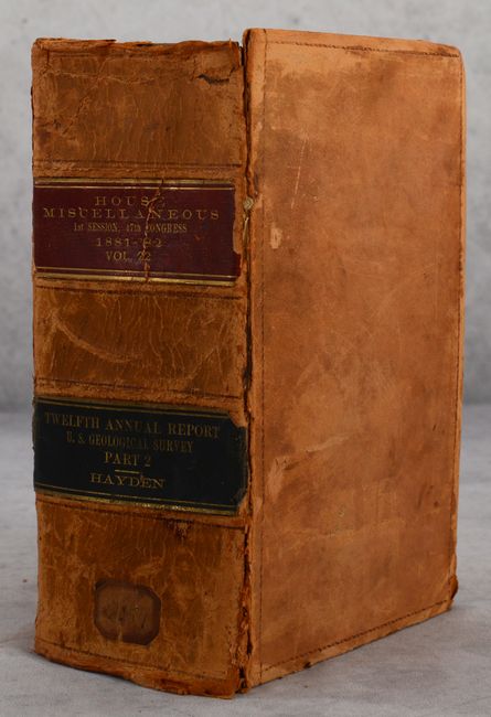
Bound at the rear of the volume are an additional 11 large folding maps of central Wyoming, southern Idaho, and northeastern Utah including a detailed geological map of Yellowstone. Wheat notes that between the two topographical and geological maps "Yellowstone cartography was placed upon a vastly higher level." Octavo, 503 pages. Hardbound in brown cloth with gilt titles on spine.
References: Wheat (TMW) #1296.
Condition: B+
Maps are very good to near fine with occasional binding tears and short fold separations. Text is mostly clean with one leaf loose and several tissue guards are stuck to the color plates. The hinges are starting and the covers are scuffed and worn.