Subject: Pacific Ocean, Western Hemisphere
Period: 1589 (dated)
Publication: Theatrum Orbis Terrarum
Color: Hand Color
Size:
19.4 x 13.4 inches
49.3 x 34 cm
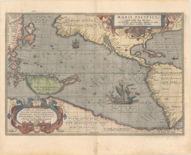
Ortelius’ seminal map of the Pacific is the first printed map devoted to the Pacific and the first to label the Americas separately as North and South subsequent to Mercator’s 1538 world map. The map draws on the cartography of Frans Hogenberg, Mercator’s world map of 1569, and Portuguese manuscript maps of Bartolomeo de Lasso. It widens the gap between Asia and North America while properly locating the Philippines and Japan, although there is an odd Isla de Plata above Japan. North America is depicted considerably narrower and more correctly at the Tropic of Cancer, and the head of the Gulf of California is shown in a new form with the R. Grande being introduced for the first time, although misplaced. The large southern continent, Terra Australis, stretches over the bottom of the map, but the name Tierra del Fuego appears south of the Strait of Magellan. The map is adorned with two elaborate cartouches and Magellan’s surviving ship Victoria is pictured along with two smaller ships. First state with the date 1589 in the lower cartouche. Latin text on verso, published in 1595.
References: Burden #74; Cohen, p. 31-33; Goss (NA) #14; Suarez (Pacific) p. 46, 65; Van den Broecke #12; Wheat (TMW) #24.
Condition: A
A nice impression on a sheet with the crossed arrows watermark commonly found on Ortelius maps. There are a couple errant spots of colorist's ink at top and a short centerfold separation in the bottom blank margin.