Subject: France
Period: 1871 (dated)
Publication:
Color: Hand Color
Size:
24.2 x 19.1 inches
61.5 x 48.5 cm
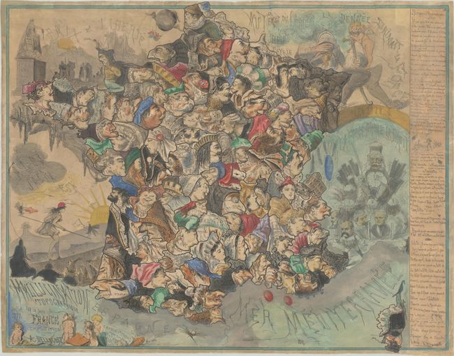
This map was published by Andre Belloguet in July 1871, shortly after several devastating events for France: the Siege of Paris, France's defeat in the Franco-Prussian War, and the failed Paris Commune. The map shows the departments of France as caricatures and contorted heads, most of which are boldly colored with the obvious exception of Alsace and Lorraine, which France had lost to Germany at the end of the war. At top left is a sun rising over the city with the motto "Paix et Liberte" (Peace and Liberty) in the sky, while below are soldiers, crosses, and a statue recognizing the revolutions of 1789, 1830 and 1848. In the Bay of Biscay is Marianne walking a tightrope with flies standing on the ends of her balancing pole, one waving a red flag and the other a white one, while her political opponents wait for her to fall. The motto "Alea jacta est" (the die is cast) fills the sky above her. To the east is Germany, represented by Emperor William I riding a chariot of cannons, led by the arms manufacturer, Krupp. Andre Belloguet (1830-73) was a French artist well-known for his anthropomorphic maps and satirical caricatures. After the Paris Commune, Belloguet fled to Belgium and worked for the Belgian satirical magazine, Le Lutin.
References:
Condition: B
Moderate soiling and toning, mounted on archival tissue to repair a number of small cracks and tears.