Subject: Ancient World
Period: 1588 (circa)
Publication: Cosmographey
Color: Hand Color
Size:
14.3 x 12.2 inches
36.3 x 31 cm
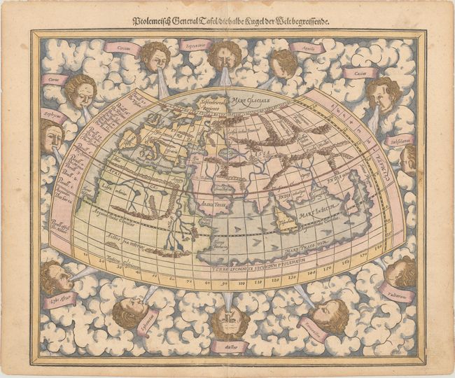
Sebastian Munster (1489 - 1552) was one of the three most renowned cartographers of the sixteenth century, along with Mercator and Ortelius. Munster's Geographia and Cosmographia Universalis were two of the most widely read and influential books of the period. His editions of Ptolemy's Geographia, published between 1540 and 1552, were illustrated with 48 woodcut maps, the standard 27 Ptolemaic maps supplemented by 21 new maps. These new maps included a separate map of each of the known continents and marked the development of regional cartography in Central Europe. The antique geography was a prelude to Munster's major work, the Cosmographia, which was published in nearly 30 editions in six languages between 1544 and 1578 and then was revised and reissued by Sebastian Petri from 1588 to 1628. The Cosmographia was a geographical as well as historical and ethnographic description of the world. It contained the maps from the Geographia plus additional regional maps and city views with nearly 500 illustrations which made it one of the most popular pictorial encyclopedias of the sixteen century.
This striking woodblock Ptolemaic map was redrawn for the later issues of Munster's Cosmographia from 1588 through 1628. The traditional classical world is surrounded by clouds and eleven wind-heads (their Latin names in banners). The continents are oddly shaped and all connected to the great southern continent, Terra Incognita Secundum Ptolemaeum. There is a very large Toprobana (modern day Sri Lanka) to the west of India in the landlocked Indian Ocean, and the Indian subcontinent is severely truncated. Southeast Asia is called India Extra. Only the northern part of Africa is shown with the Nile originating in a series of lakes in a large mountain range. German text and an interesting illustration of a wind rose on verso.
References: Shirley (BL Atlases) T.MUN-1l #2; Shirley #162.
Condition: B+
On watermarked paper with light soiling and dampstaining along the upper edge, well away from map image.