Subject: Southwestern Colorado
Period: 1898-1902 (dated)
Publication:
Color: Printed Color
These highly detailed maps were published as part of the USGS 15-minute quadrangle series and show remarkable detail of this mountainous and mineral rich region of southwest Colorado.
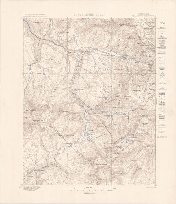
A. Topographic Sheet - Colorado - Telluride Quadrangle, dated 1898 (13.9 x 17.6"). Depicts the vicinity of Telluride including Silver Mountain, Lookout Peak, and Mt. Wilson. Locates the Rio Grande Southern Railroad along with the Telluride Branch that splits off at Vance Junction. A legend at right further identifies streams, lakes, ponds, trails, triangulation stations, and more. Compiled from surveys taken in 1894. Condition: Clean and bright with a faint dampstain confined to the top right sheet edge, well away from the map image. (A)
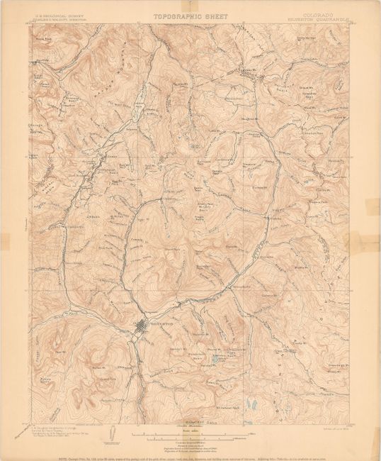
B. Topographic Sheet - Colorado - Silverton Quadrangle, dated 1902 (14.2 x 17.5"). Presents the region around Silverton including the Animas River, Hayden Mountain (named after noted geologist Ferdinand V. Hayden), and Sneffels. The map identifies several railroads in the area including the Silverton & Northern Railroad, Denver and Rio Grande, and the Gladstone & Northern. Other details include numerous creeks, rivers, gulches, basins, peaks, and more. Compiled from surveys taken in 1895 and 1900-01. Condition: Folded by a previous owner with old repairs on both recto and verso to several small separations and tiny edge tears in the margins. Tape on recto just enters the border at right and bottom. (B)
References:
Condition:
See description above.