Subject: Colonial New England & Mid-Atlantic United States
Period: 1755 (dated)
Publication: Atlas Universel
Color: Hand Color
Size:
24.5 x 18.8 inches
62.2 x 47.8 cm
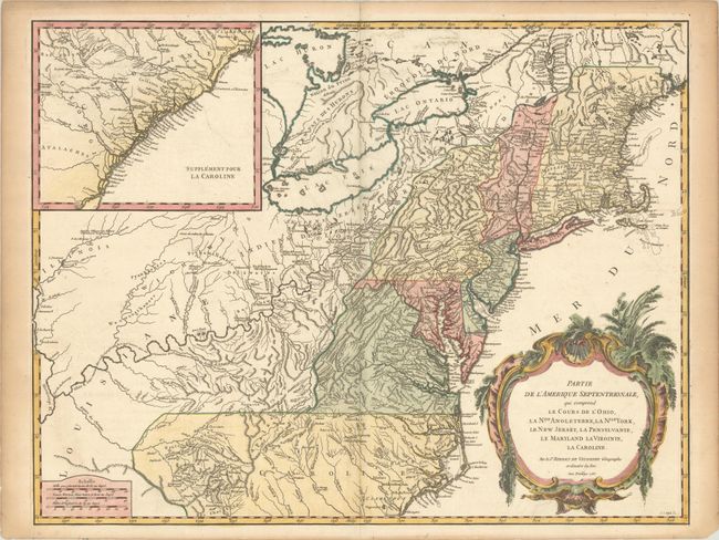
Beautifully engraved large map of the colonies between the Ohio and Mississippi rivers and the Atlantic with an inset at upper left that continues the main map from Cape Fear south through the Carolinas and Georgia to F. St. Georges. It is based on the seminal map by John Mitchell that was published in the same year this plate was engraved. The mapping of the trans-Allegheny and Great Lakes regions and in the interior of New England is of particular interest, for this shows some of the earliest accurate information of these regions incorporating data from the Mitchell, Evans, and Fry-Jefferson maps. Also of great interest is the region known as the Forks of the Ohio (confluence of the Allegheny and Monomgahela rivers) and the location of French Fort Duquesne – the region hotly disputed during the French and Indian War. It is embellished with a large title cartouche engraved by Marie Catherine Haussard. This is the first state of the map, with Louisiane in the western frontier and borders that predate the 1763 Treaty of Paris. It was published in 1757 as part of the first edition.
References: Cumming (SE) #295; McCorkle #755-37; Pedley #469; Sellers & Van Ee #718.
Condition: A
A crisp impression on watermarked paper with minor offsetting and light toning in the blank margins.