Subject: Colonial Northern United States & Canada, Great Lakes
Period: 1761 (circa)
Publication: Natural and Civil History of the French Dominions in North America
Color: Black & White
Size:
21.1 x 12.4 inches
53.6 x 31.5 cm
Thomas Jefferys was one of the most important English map publishers of the 18th century. His work included prints and maps of locations around the world, but his most notable maps are of North America and the West Indies. He began his career in the map trade in the early 1730s, working as an engraver for a variety of London publishers, and eventually setting up his own shop. In 1746, he was appointed Geographer to the Prince of Wales, and in 1760 he became Geographer to the King. These titles granted access to manuscripts and cartographic information held by the government. In the early 1760s he embarked on an ambitious project to produce a series of English county maps based on new surveys, but ran out of money and filed for bankruptcy in 1766. He then partnered with London publisher Robert Sayer, who reissued many of Jefferys plates and continued to issue new editions after Jefferys' death in 1771. Jefferys' American Atlas and the accompanying West-India Atlas, published post posthumously, are considered his most important cartographic works.
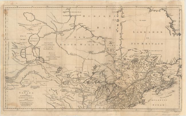
This scarce and fascinating map focuses on the northern United States and Canada. The Great Lakes are prominently shown, with numerous fictitious islands in Lake Superior, including the infamous I. Minong that continued to appear on maps, and eluded explorers' searches for it, well into the 19th century. There is plenty of detail in the colonies along the coast, including towns and cities (among them Pittsburgh, Philadelphia, New York, and Boston), rivers, and topography. The land immediately to the west of Pennsylvania is labeled Virginia, with the land father west identified as Louisiana. Numerous Indian tribes are located, including Iroquois, Sioux, Miamis, and Algonquins. There is a large conjectural strait, labeled Very doubtful leading from Hudson's Bay to B. of Hopes Advance. The River of the West is traced in the westernmost area of the map, with a dotted line branching off of it depicting the warriors track from the River of the West. Several notes in the west refer to the uncertain mapping of the region's rivers, and a large note reads This Land according to Mr. Jeremiah is more temperate than Hudsons Bay.
References: Karpinski (MI) #LXXVI; Tooley (Amer) p. 317.
Condition: B
A nice impression issued folding, now flat, with light toning and soiling, and a few small stains. There are professional repairs to several fold separations, tears, and a small chip at left with a minor amount of neatline replaced in facsimile. The map has been remargined at right with a small portion of the map border also skillfully replaced in facsimile.