Subject: Tahiti
Period: 1769-90 (circa)
Publication:
Color:
Captain James Cook (1728-1779) is best known for his three voyages to the Pacific (1768-71; 1772-75; and 1776-79). His discoveries radically changed the western understanding of the world in the late 18th century. He was the first to circumnavigate and chart New Zealand and provided the earliest European accounts of exploration along the eastern coast of Australia and the Hawaiian Islands. On February 14th, 1779, he was killed on Hawaii after attempting to kidnap the chief of the island.
Many contemporary accounts of Cook’s voyages, including charts and engravings, appeared in the late 18th century. The first official account of Cook’s first voyage was published in 1773 by John Hawkesworth in Volumes II and III of An Account of the Voyages Undertaken by the Order of His Present Majesty for Making Discoveries in the Southern Hemisphere... William Strahan and Thomas Cadell published the first official accounts of the second and third voyages in 1777 and 1784. Accounts of his exploration were subsequently translated into French, German, and Dutch.
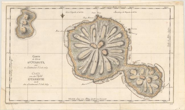
A. Carte de l'Isle d'Otahiti / Carte von der Insel Otaheite, from Ausfuhrlich und Glaubwurdige Geschichte der Neuesten Reisen um die Welt..., published 1774, hand color (16.1 x 9.4"). This chart of the islands of Tahiti is one of the earliest depicting the island and is a product of Cook's first voyage. It is fully engraved to show the island's unique mountainous topography and the rivers that radiate from the centrally located mountain or volcano. Cook's first expedition was spurred by a petition by the Royal Society to King George III requesting a scientific expedition to the Pacific to study and observe the 1769 transit of Venus across the sun from the island of Tahiti. In addition to the approved scientific voyage, the Admiralty embarked on a confidential mission to search the South Pacific for signs of the postulated continent Terra Australis Incognita. Published in the second volume of the German edition of Hawkesworth's Voyages Around the World Undertaken by the Order of His Present Majesty... Engraved by F.G. Berger. Condition: A crisp impression issued folding, now flat, on watermarked paper. There are a few archivally repaired tears and minor soiling. The margins have been extended at top and at bottom left, with a small piece of tape entering the map image at left.
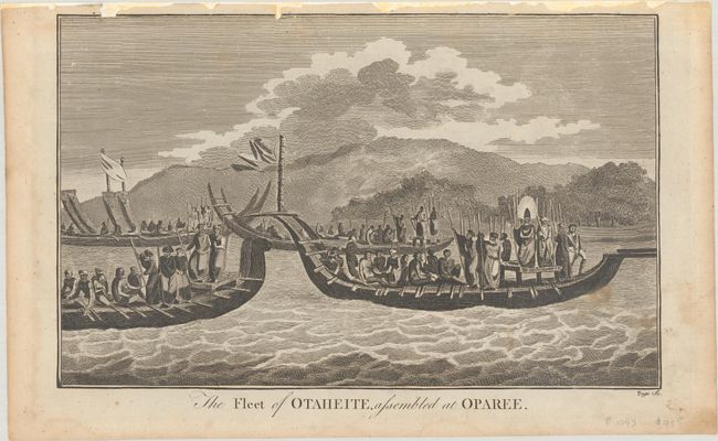
B. The Fleet of Otaheite, Assembled at Oparee, circa 1790, black & white (13.1 x 8.2"). This striking engraving depicts a Tahitian king on a war canoe in the bay. Adapted from a sketch by William Hodges, the official artist on Cook's second voyage. Engraved by Page. Condition: A dark impression with the top border reinforced with paper to reinforce and repair a few chips that just enter the border. There is light foxing and soiling.
References:
Condition: B+
See description above.