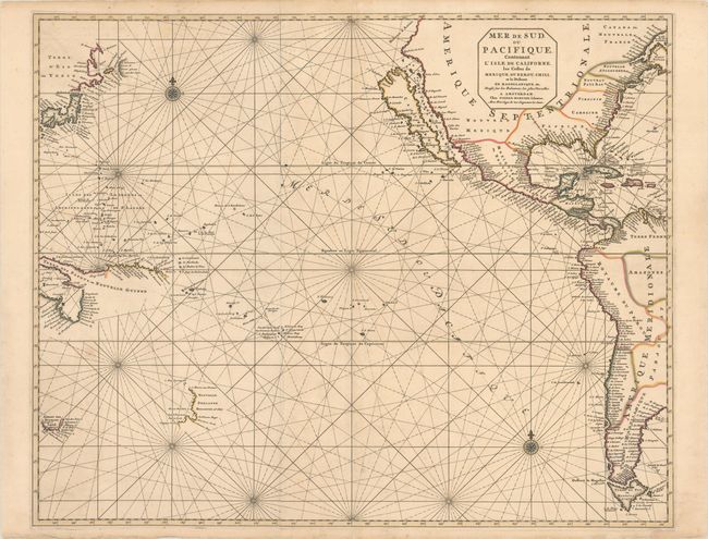
Subject: Pacific Ocean
Period: 1700 (circa)
Publication: Le Neptune Francois
Color: Hand Color
Size:
29.3 x 23.5 inches
74.4 x 59.7 cm
While focused on the Pacific Ocean, this uncommon and dramatic sea chart covers nearly all of North America and a good deal of South America. It prominently features the island of California using the information from Luke Foxe's map of the region with bays on the northern coast, an array of islands in the Mer Vermeio, and the large Agabela de Gato peninsula shown in the Pacific Northwest. The island of Japan is shown with an amorphous Hokkaido named Terre d'Eso ou Yedso from the de Vries expedition. Partial coastlines are mapped for New Zealand, Northern Australia, Tasmania and New Guinea.
Le Neptune Francois was the most expensive sea atlas published in Amsterdam during the latter part of 17th century. This map is from the expanded atlas with the Suite du Neptune Francois, ou Atlas Nouveau des Cartes Marines, a group of maps copied by Nicolas Fremont d'Ablancourt from manuscript maps collected by the Portuguese crown; a rare occurrence because Portugal was notorious for keeping their geographical sources secret. Printed on two sheets, joined as issued.
References: McLaughlin #137; Tooley (America) p.127, #64; Tooley (MCC-23) #57; Wagner #440.
Condition: B+
A crisp impression with contemporary outline color. There is minor foxing and several cracks caused by the oxidation of green pigment that have been repaired on verso with archival materials. A number of short edge tears confined to the blank margins have also been archivally repaired on verso.