Subject: Polar
Period: 1740 (circa)
Publication:
Color: Hand Color
Size:
20.3 x 18.2 inches
51.6 x 46.2 cm
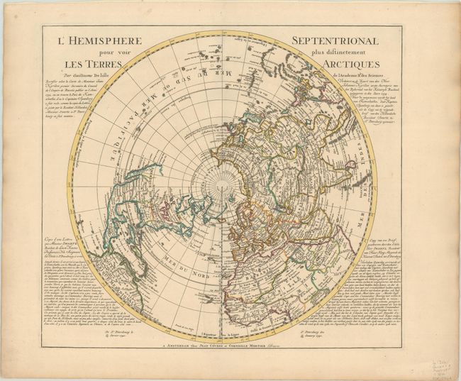
This is a matching set of maps of the northern and southern hemispheres, originally produced by Guillaume Delisle in 1714 and reissued by Covens and Mortier. The map of the northern hemisphere went through several revisions to reflect later discoveries. This version is derived from Ivan Kyrilow's 1734 map of the Russian Empire and from Spanberg and Bering's discoveries in northeast Asia. California is correctly shown as a peninsula, but with a dotted line still hinting at the possibility of the island form. The entire northwest coast is blank above Cap Blanc. Terre de la Compagnie appears off the northeast coast of Asia with a note about its discovery by Jean de Gama. Above that the map now includes a fairly accurate depiction of Kamchatka. Text panels have been added to include a letter (printed in French and Dutch), dated Jan. 13, 1740, from Mr. Swartz, Dutch ambassador at St. Petersburg, announcing Lt. Morten Spanberg's recent discoveries in the vicinity of Kamchatka and noting his competition with Bering.
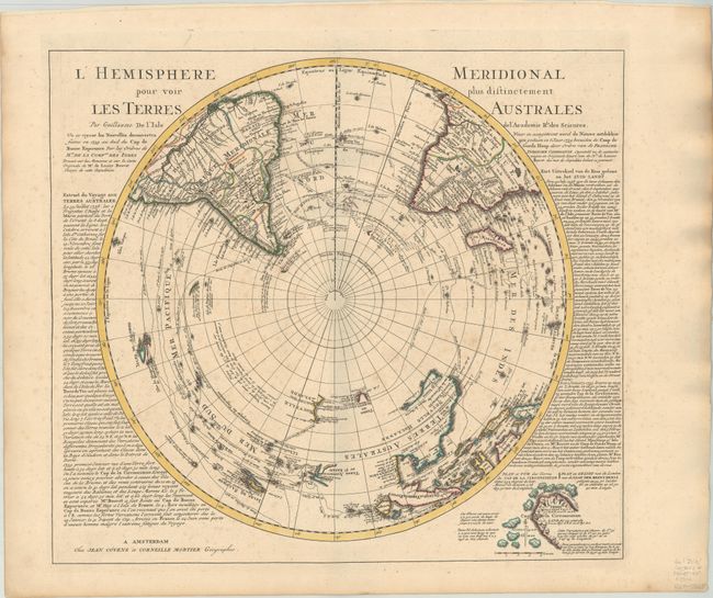
The map depicting the Southern Hemisphere shows the tracks of the explorers and circumnavigators around the southern oceans including Magellan in 1520, Abel Tasman in 1642, and Edmund Halley in 1698-1700. The map provides very good detail, particularly of the explorations and discoveries in the South Pacific. Australia, New Guinea, Tasmania, and New Zealand are partially delineated, with Australia and New Guinea nearly attached to one another. Although Covens & Mortier's edition is nearly identical to Delisle's map cartographically, Cap de la Circoncision was added just south of Africa and also in an inset outside the hemisphere at bottom right based on the recent discovery by Jean-Baptiste Charles Bouvet de Lozier in 1739. The cape was part of Bouvet Island, later named after the explorer, and was not sighted again for nearly 70 years due to Bouvet mislabeling the coordinates of the land he sighted. Text panels surrounding the map were also added.
References: Tooley (Australia) p. xxxi, #42; Wagner #504.
Condition:
The maps have crisp impressions with contemporary outline color on sturdy sheets. The map of the northern hemisphere is in near fine condition (A), while the map of the southern hemisphere is in very good condition (B+) with light, scattered foxing.