Subject: Southwestern United States & Mexico, Arizona Territory
Period: 1857-58 (dated)
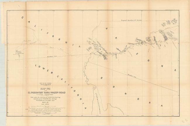
Publication: Wagon Roads... A Report Upon the Several Roads Constructed...
Color: Black & White
Size:
35.4 x 21.9 inches
89.9 x 55.6 cm
In 1857, the U.S. Congress passed the Pacific Wagon Road Act, allowing the survey and construction of wagon roads. Issued as part of Albert Campbell’s Wagon Roads... A Report Upon the Several Roads Constructed, this map details the section of the important southern route between the Pima Villages near present-day Phoenix and San Diego. This road improved Cooke’s Road with several shortcuts. The map provides explicit detail including water tanks, wells, mail stations, gold mines, camps, and more. Of particular interest is the proposed boundary designating the territory of Arizona in the southern portion of New Mexico Territory. This is the only government published map to show this configuration, all others being commercial publications. Much of the information on the map is derived from maps from the Mexican Boundary Commission.
Carl Wheat devotes a chapter to the wagon road project, concluding "The Department of the Interior was caught up in the currents that surrounded the oncoming Civil War, and little came of the imposing wagon road program that it had set in motion. [However] its efforts were of great effect on all parts of the West."
References: Howes #C-86; Wagner-Camp #321,
Condition: B
Issued folding and now flattened and backed with tissue. There is light toning along the fold lines.