Subject: World, Americas & Africa
Period: 1772-92 (dated)
Publication:
Color: Hand Color
Three rare matching maps of the world, North America, and Africa by prominent 18th century Spanish mapmaker Tomas Lopez.
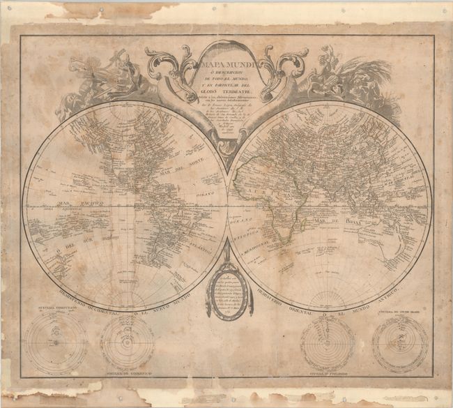
A. Mapa Mundi o Descripcion de Todo el Mundo y en Particular del Globo Terrestre..., dated 1792 (23.0 x 19.0"). This decorative double-hemisphere world map shows a reasonably well developed western North American coastline with numerous place names identified along the coast. Individual states are labeled along the east coast, and a number of place names are located in Louisiana and New Mexico including Natchitoches, Cenis, El Paso, Santa Fe, and Taos. The Great Basin and Pacific Northwest are void of detail. Both Australia and New Zealand have full coastlines, but the southern coast of New Guinea is still incomplete. The ornate title cartouche is balanced by four theories of the universe, including models by Copernicus, Ptolemy and Brahe.
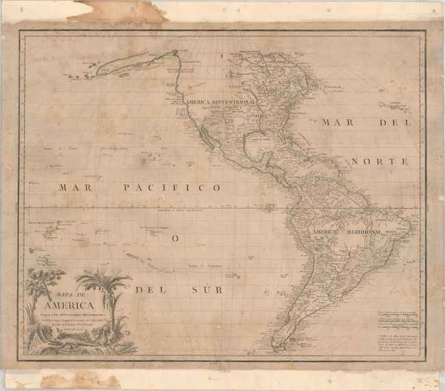
B. Mapa de America Sujeto a las Observaciones Astronomicas, dated 1772 (23.6 x 19.2"). This map was issued 9 years after the conclusion of the French & Indian War and shows the North American continent divided between Britain and Spain along the Mississippi River. It is particularly notable for being the second printed map to locate San Francisco Bay, preceded only by the 1771 map of the California coast by Miguel Costanso and also engraved by Lopez (San Francisco Bay was not found on another map until 1790). This pre-Captain Cook map is also noteworthy for its early depiction of Hawaii, here noted as "Tierra descubierta por Mendana". This is in reference to Spanish explorer Alvaro de Mendana y Neira, who Spain claimed had visited Hawaii on his 1568-69 return journey from the Solomon Islands to Mexico, over 200 years before Captain Cook visited the islands. Cartographically, the British colonies are located along the eastern seaboard with Indian tribes to their immediate west. Spanish possessions include Louisiana, New Mexico, and an area labeled Florida extending from the Rio Grande to the Mississippi River in present-day east Texas and Louisiana. The Pacific Northwest is mostly void of detail except for an uncertain "Rio Que Cerre al Oeste" extending from Lake Winnipeg. In South America, the spurious lakes Parime and Xarayes are depicted. Adorned by a decorative title cartouche featuring a menacing crocodile.
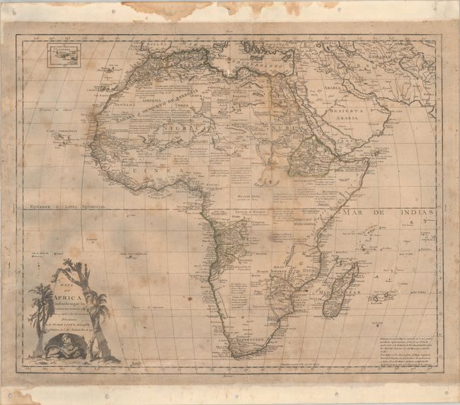
C. Mapa de Africa, Construido Segun las Noticias Mas Modernas y Ciertas..., dated 1790 (23.4 x 18.5"). A handsome large map of Africa depicting typical late 18th century knowledge of the continent. The Nile is shown originating from tiny twin lakes adjacent to the Lunar Mountains located above the equator. The map shows good detail of kingdoms and tribes along the coast including Monomotapa, Hotentotes, Congo, and Abisinia. The interior is filled with copious notations. Adorned by a decorative title cartouche featuring a fierce lion holding its prize - a human head.
These Spanish maps are rare on the market with only a few past sales records in the last 30 years.
References: Wagner #626 & #629.
Condition: C+
All maps have contemporary outline color, are backed with linen, and have binding holes in the linen outside of the maps. There is light toning, foxing and staining, small repaired tears, and a few tiny areas of paper loss in the image. Dampstains at top and bottom are almost entirely outside of the image. The maps have been stored rolled and do not currently lay flat.