Subject: Colonial Florida
Period: 1765 (circa)
Publication:
Color: Hand Color
Size:
8.8 x 7.3 inches
22.4 x 18.5 cm
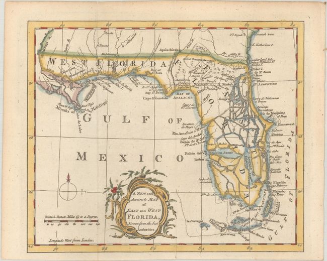
East and West Florida underwent several boundary and sovereignty changes during its history. The two regions were established in 1763 by the British colonial government out of land taken from France and Spain after the French and Indian War. Reasoning the newly acquired territory too large to govern, the British divided it into two new colonies separated by the Apalachicola River.
West Florida was based in Pensacola, and the colony included the part of formerly Spanish Florida west of the Apalachicola, plus the parts of French Louisiana taken by the British. Its northern boundary shifted several times over the years. East Florida has as its capital St. Augustine, which had been the capital of Spanish Florida.
Both remained loyal to the British crown during the Revolutionary War, and served as havens for Tories fleeing the Thirteen Colonies. In 1781 Spain invaded West Florida and captured Pensacola, leading Britain to cede both to Spain following the war. The ill defined boundaries led to a series of border disputes between Spain and the nascent United States known as the West Florida Controversy. Disagreements with the Spanish government led settlers along the gulf coast to declare the area the independent Republic of West Florida in 1810. The area was soon annexed by the United States, claiming the region as part of the Louisiana Purchase. The remainder of West Florida and all of East Florida were purchased by the United States in 1819 under the terms of the Adams–Onís Treaty. Florida Territory was formed as a result.
This interesting chart covers Florida and the region as far north as Savannah. West Florida extends to the Mississippi River. It shows the entire peninsula as an archipelago that is heavily fragmented with numerous large waterways that communicate between the Gulf and the Atlantic Ocean. Tampa Bay is here named Bahia del Espiritu Santo. The map also shows the Keys and extends to include las Tortugas. A rococo-style title cartouche, distance scale with British Statute Miles, and simple compass rose with fleur-de-lys decorate the map. This map is very similar to one of the same title that was issued in the London Magazine in 1765. No engraver's signature.
References: Seller & Van Ee #1620; cf. Jolly #LOND-243.
Condition: A
A nice impression issued folding.