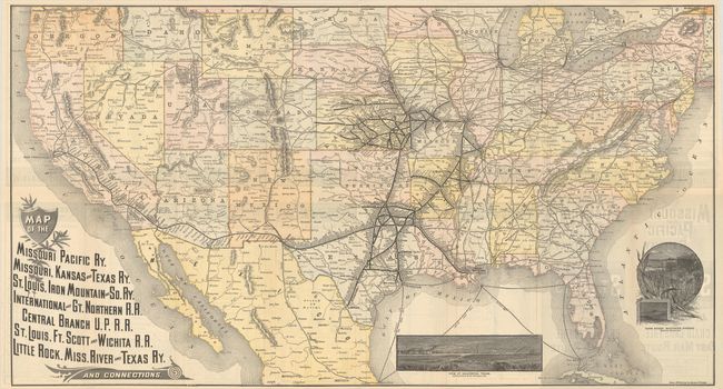
Subject: United States, Railroads
Period: 1887 (dated)
Publication:
Color: Printed Color
Size:
31 x 16.8 inches
78.7 x 42.7 cm
This folding map and timetable was published for the Missouri Pacific route, which used the railroads of the Missouri Pacific; Missouri, Kansas and Texas; St. Louis, Iron Mountains and Southern, International and Great Northern, Central Branch of the Union Pacific, and several more. The major routes originate in St. Louis and travel westward though Missouri and to the south into Indian Territory and Texas. The map shows, in small line, all railroads in the United States as well as numerous ocean routes. With a nice agriculture-themed inset titled "Farm Scene, Southern Kansas" and another showing a "View at Galveston, Texas" with ships and a formation of ducks in the foreground. Includes an extensive timetable on verso and self-folds into pictorial wrappers. Printed by Rand McNally and dated July 15, 1887 on the rear wrapper. A nice ephemeral piece that documents the continuing westward rush during the 19th century.
References:
Condition: B+
Issued folding with a few small separations at the fold junctions.