Subject: Western Hemisphere - America
Period: 1812 (dated)
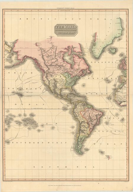
Publication: Pinkerton's Modern Atlas
Color: Hand Color
Size:
20.3 x 27.6 inches
51.6 x 70.1 cm
This large and visually stunning map of the Western Hemisphere comes from Pinkerton's uncommon atlas. It is beautifully engraved to show the Americas in surprising detail. The routes and dates of exploration by Captains Cook, Clarke, Vancouver, and La Perouse are delineated. West of the Mississippi is a vast Louisiana Territory. The upper Missouri River is shown "according to Capn. Lewis," with an outdated conjectural course depicted farther north. The R. de St. Buenaventura empties into the Valle Salado in present-day Utah. New Albion stretches from Mt. Hood to the San Francisco Bay. There is good detail along the northwest coast of America to include the majority of the Aleutians. The map shows all islands in the South Pacific to 180° W longitude. In the southern Atlantic, both South Georgia and South Sandwich Islands appear, although Sandwich Land appears as a mostly contiguous coastline rather than a chain of islands. The map was drawn under Mr. Pinkerton's direction by L. Hebert and published by Cadell & Davies & Longman, Hurst, Rees, Orme, & Brown.
References:
Condition: B+
There is light soiling along the centerfold and a 2.5" centerfold separation at left that has been closed on verso with archival materials.