Subject: Pacific Islands, World War II
Period: 1944 (dated)
Publication: Time Magazine
Color: Printed Color
Size:
32.4 x 33.4 inches
82.3 x 84.8 cm
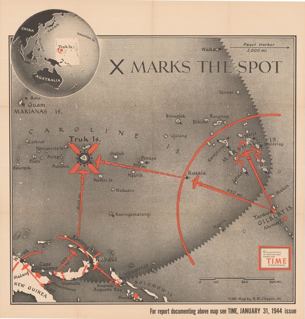
This map is an enlarged edition of a map by R. M. Chapin, Jr. that was published in the 31 January 1944 issue of Time Magazine. The map focuses on Truk Island, marked with an "X," which was an important base for the Imperial Japanese Army. The map shows the ways in which Truk Island could be targeted by the United States Navy, and accompanied an article about the theater of war in the Pacific Ocean. The article explained the importance of Truk: "The biggest primary obstacle along the Central Pacific route—or MacArthur's Southwest route—is Truk, heart of Japan's Pacific outposts. Truk stands at the head of the steppingstones which lead westward to the Philippines, and thence to China's eastern coasts. It provides refuge for the Jap Fleet, bases for air reinforcements which can be rushed to any point of Japan's lower periphery of oceanic forts. If any point can be "impregnable," Truk should be. It is a group of eleven hilly, defensible islands set in a 30-mile-wide lagoon and encircled by a coral reef. Inside the reef, these islands can be shelled by capital ships standing off the reef, can be bombed from the air. Tarawa taught that they cannot be knocked out. Landing forces would have to thread the four narrow openings in the reef—a task which would not be worth the cost if Truk could be neutralized by seizing less formidable islands near by. If Truk is not necessarily a point to occupy, it is certainly one to make useless to the enemy."
References:
Condition: A
Clean and bright with a few short separations at fold intersections.