Subject: North Pacific Ocean
Period: 1802 (published)
Publication: Voyage dans le Nord de la Russie Asiatique...
Color: Black & White
Size:
24.1 x 15.6 inches
61.2 x 39.6 cm
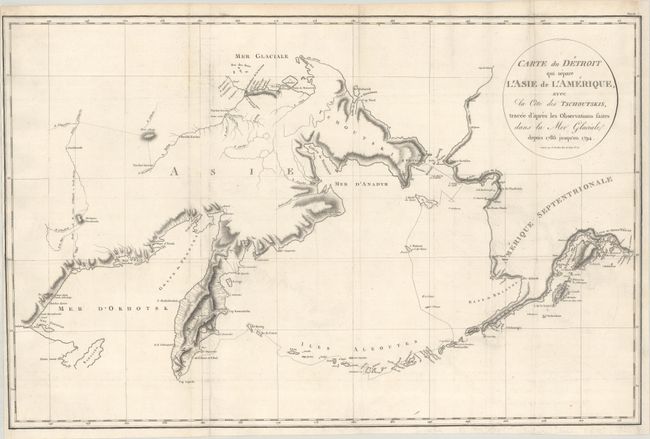
This scarce map is focused on the Bering Strait between Asia and North America. It describes the area from the Chukchi Sea and peninsula, Kamchatka, and the Sea of Okhotsk across the Bering Strait to the Seward Peninsula, Bristol Bay, and the Alaskan Peninsula. The map also details the Aleutians, Kodiak Island, and a bit of the Gulf of Alaska. The North American coastline extends as far south as Prince William Sound and Cook Inlet. The map delineates the eight year geographical and astronomical expedition led by Commodore Joseph Billings of the British Royal Navy from 1786 to 1794. Billing's track leads from P. de St. Pierre et St. Paul in Kamchatka along the Aleutians to Ounalaschka, north to I. Mattoui ou I. de Gore, I. de Clerke, Point de Rocher, and then to the B. de St Laurent on the Bering Strait. This map is from the French edition of Martin Sauer's account of the expedition. Engraved by B. Tardieu.
References:
Condition: B+
Issued folding, now flat, on watermarked paper with some minor offsetting. The bottom left margin and the entire right margin have been professionally replaced, with the neatline in facsimile. There are old library stamps on verso marked "free."