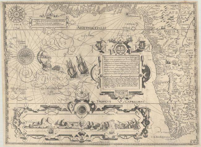
Subject: Western Africa
Period: 1598 (published)
Publication: His Discours of Voyages to the East and West Indies
Color: Black & White
Size:
20.3 x 15.1 inches
51.6 x 38.4 cm
This splendid map, from the English edition of Jan Huygen van Linschoten's Itinerario, is one of the most richly ornamented maps in early cartography. It was originally designed by Arnold Floris van Langren and was re-engraved for this edition by Robert Beckit. The map covers the southwestern coast of Africa from the Gulf of Guinea to just beyond the Cape of Good Hope with excellent detail along the coastline. The fictitious cities of Vigiti Magna and Monomotapa are located and most place names and geographical features have Portuguese nomenclature. The mainland is embellished with snakes, an elephant, a rhinoceros, a lion and a pair of sirens in Lake Zaire. The balance of the sheet is filled with fabulous cartouches, the Portuguese arms, elaborate compass roses, sailing ships and a sea monster. The large bottom cartouche encloses views of Ascension and St. Helena Islands; important refueling ports in the route around Africa. The English title is in the lower part of the cartouche, "The Description of the Coast of Guinea, Manicongo, and Angola, and to Proceeding Forwards beyond the Cape de Bona Speranza…" This English edition is very uncommon.
References: Norwich #239a; Tooley (MCC-29) #167; Tooley et al [Landmarks] pp. 168-69.
Condition: A
Issued folded, now flattened on a sheet with a bunch of grapes watermark with professional repairs at fold intersections. The side margins have been extended (leaf casting method) to accommodate framing and a binding tear at left has been expertly repaired.