Subject: South America
Period: 1850-74 (circa)
Publication:
Color: Hand Color
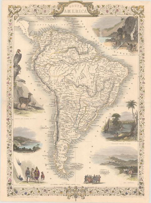
A. South America, by John Tallis, from The Illustrated Atlas, and Modern History of the World, circa 1850 (9.5 x 13.8"). This is a very lovely and well-engraved map of South America. It is filled with detail, including rivers, lakes, towns, and villages, and many place names along the coast. The continent is surrounded by eight vignettes and a decorative border and title cartouche. The vignettes show gold mining in Brazil, a Brazilian rope bridge, condors and llamas of Peru, natives of Chili, Valparaiso, figures descending the Cordilleras, natives transporting a barrel, and a view of Rio de Janeiro. John Rapkin drew and engraved the map. The vignettes were illustrated by J. Marchant and engraved by J. Rogers. Condition: There are some short edge tears, including two that enter the border at top and bottom. Centerfold separations at left and right have been repaired on verso with archival materials. (B+)
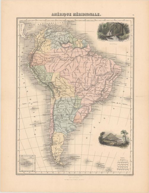
B. Amerique Meridionale, by J. Migeon, from Geographie Universelle Atlas-Migeon, published 1874 (10.9 x 14.6"). This lovely map of the continent comes from one of the more decorative atlases of the late 19th century. It includes many place names and good detail of the rivers and mountains. There are two vignettes at right, depicting Foret Vierge and an unnamed city against a mountainous backdrop, perhaps Potosi. An inset at bottom left shows the Galapagos. Drawn by Desbuissons and engraved by Sengteller, with lettering by Isid. Dalmont. Condition: There is minor soiling and marginal toning. (A)
References:
Condition:
See description above.