Subject: Florida
Period: 1837-38 (published)
Publication: H.R. Doc. 78, 25th Congress, 2nd Session
Color: Black & White
Size:
5.6 x 9 inches
14.2 x 22.9 cm
This fascinating set of maps relates to the Indian Wars in Florida. They are included with the robust 832-page report documenting the military court proceedings examining the conduct and failed campaign by General Scott during the Second Seminole War (he was later exonerated). The maps include:
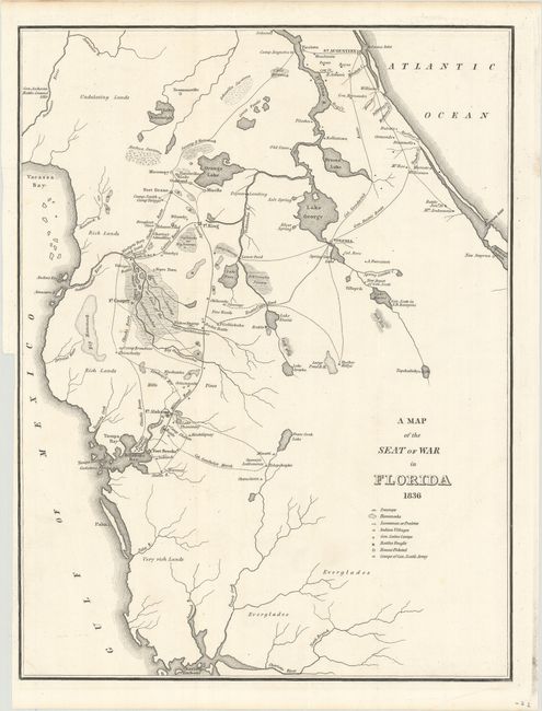
A. A Map of the Seat of War in Florida, dated 1836 (11.1 x 14.7"). This is the first map by Major Gen. W. Scott to show the progress of the Seminole Wars. The map shows much of northern Florida from Charlotte Harbor in the southwest to St. Augustine in the northeast. Locates Tampa Bay, Lake George, Drums Lake, and numerous forts including Drane, Izard, Cooper, Alabama and Brooke. Delineates the routes of Gen. Eustis, Col. Goodwin, plus the Military Road from Fort Brooke to Fort King. Locates swamps, fords, numerous small settlements and a few battle sites. Many interesting place names like Negro Town, located northeast of Fort Cooper on the edge of the Great Swamp or the Cove of the Ouithlacoochee.
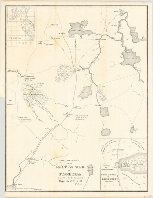
B. Copy of a Map of the Seat of War in Florida Forwarded to the War Department by Major Genl. W. Scott U.S.A., dated 1836 (12.2 x 15.8"). This map covers from Pilatka to Tampa Bay and shows the various battle grounds and troop movements through the region. Small inset at top shows the whole state of Florida. At lower right the larger inset is the Battle Ground of Major Dade. It locates the position of the Indians at various stages of the Advance Guard and more.
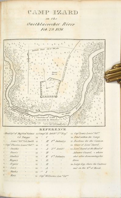
C. Camp Izard on the Ouithlacoochee River Feb. 29. 1836, dated 1836 (4.6 x 3.9"). This map shows the fort and locations of Indians on February 28 and 29, 1836. The fort was "Burnt Dec. 29." Locates the "Indians on 28 Feb. concealed by Palmettos." The legend locates troop headquarters and positions, the location of Lieut. Izard's grave, and more.
Octavo, hardbound in contemporary leather (front cover missing). The first two maps are loose and the Camp Izard map is still bound into the volume. The report is housed in archival paper covers.
References: Claussen & Friis #151, 152 & 153.
Condition: B+
Condition code is for the folding maps, which are mostly clean and bright with a bit of faint scattered foxing. Text has light toning and scattered foxing. The report's front cover is missing and the spine and rear cover are scuffed and worn.