Catalog Archive
Auction 185, Lot 239

"Map of Oregon and Upper California from the Surveys of John Charles Fremont and Other Authorities [in report]", Fremont/Preuss

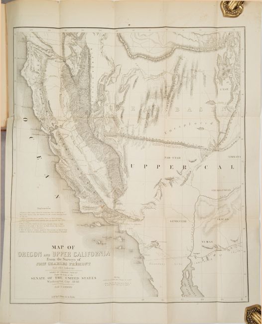
Subject: Western United States

Period: 1850 (published)

Publication: H.R. Doc. 17, 31st Congress, 1st Session

Color: Black & White

Size:
16.6 x 19.5 inches
42.2 x 49.5 cm
Download High Resolution Image
(or just click on image to launch the Zoom viewer)

John C. Fremont is an important historical figure best remembered for his three explorations of the west in the 1840s. Fremont married Jessie Benton, daughter of Sen. Thomas Hart Benton in 1841. The Senator championed the idea of Manifest Destiny, pushing for national surveys of the West and arranging for his son-in-law to lead them.

From 1842 to 1846 Fremont led three explorations of the west with Kit Carson as guide and Charles Preuss as the topographer. His early route became know as the Oregon Trail and his explorations are credited with encouraging the huge overland migration to the west. He was the first American to see Lake Tahoe, and finally determined that the Great Basin is endorheic, or closed basin with no outlet to the sea.

Fremont went on to become a millionaire, a California senator, a governor to Arizona Territory, the man who is credited with saving Kit Carson's life, and much more, yet died penniless and in virtual obscurity. Some scholars regard Fremont as a hero of significant accomplishment, while others view him as a failure who repeatedly defeated his own best ideals. He remains an enigmatic figure in the history of the United States. Read more of his fascinating story here.

This is the smaller version of Fremont's highly respected map of the American West. It was published by Congress to meet the demand for information concerning the California Gold Rush. Wheat noted that the map and accompanying text had "a two-fold importance in history, first as contributions to geographical and cartographical knowledge in the year 1848 and second as historical documents concerning Fremont's notable Third Expedition." Fremont’s map is unquestionably one of the most important American maps of the 19th century.

The map covers a smaller area than his larger map of the same title, eliminating Oregon and covering California and only the western parts of present-day Arizona and Utah. The El Dorado or Gold Regions are shown on the south fork of the American River and the upper course of the Feather River. It contains Fremont's famous topographical error, showing an east-west mountain range across the unexplored area of the Great Basin. The map was "Drawn by Charles Preuss under the Order to the Senate of the United States, Washington City 1848." Lithography by the Baltimore firm of E. Weber & Co.

The map is still bound into the 944-page report with an additional 3 maps at the rear of the volume including "Map of Fort Hill" in the vicinity of Monterey, California. Octavo, rebacked in leather with original spine labels and original leather boards.

References: Wheat (TMW) #613; Wheat (Gold) #41.

Condition: B+

The folding map is very good with a few spots of foxing and a 2.5" edge tear at left that has been closed on verso with archival materials. The smaller folding "Map of Fort Hill" also has a repaired 4.5" edge tear at left. Text is mostly clean and tight with some light toning to the index (first 15 pages or so). Rebacked with original boards which are worn and scuffed.

Estimate: $500 - $650

Sold for: $425

Closed on 11/17/2021

Archived