Subject: Upper Midwestern United States
Period: 1835 (dated)
Publication: Report of a Geological Reconnoissance Made in 1835...
Color: Black & White
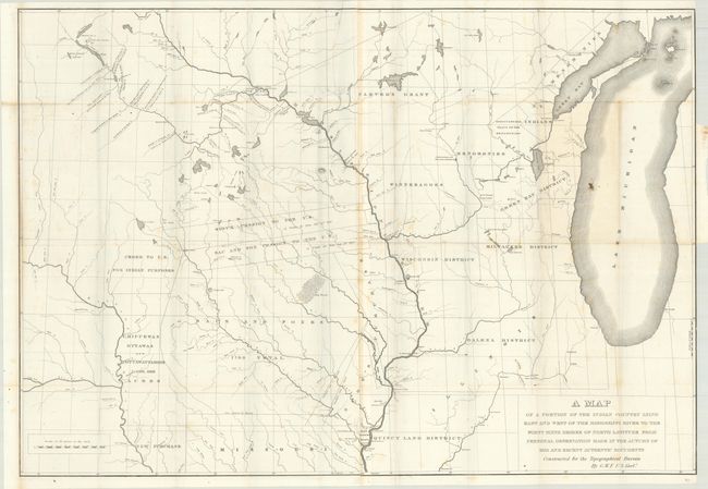
A. A Map of a Portion of the Indian Country Lying East and West of the Mississippi River to the Forty Sixth Degree of North Latitude... (38.0 x 26.3"). This interesting and expansive map is considered to be among the best maps of the upper Mississippi River published prior to Nicollet's landmark map of 1843. The map is centered primarily on Iowa, with part of Wisconsin and northern Illinois. It shows the Indian Districts, the Half-Breed Tract at the juncture of the Mississippi and Des Moines rivers, forts, and trading posts. The French and Indian names for many of the rivers are noted. Also shown are the lands ceded to the United States from various Indian tribes, Carver's Grant, and the town of Commerce, Illinois, which would be purchased by the Mormons a few years later and renamed Nauvoo.
The map was prepared by George William Featherstonhaugh, a British-American geologist and geographer, who was the first geologist hired by the U.S. government. Featherstonhaugh was charged with exploring a portion of the Louisiana Purchase between the Missouri and Red Rock Rivers. From 1835-37, Featherstonhaugh traveled by canoe along numerous rivers in the region, including the Fox River, Wisconsin River, Mississippi River, Minnesota River, St. Croix River, Tennessee River, and Ohio River. This map was published in Report of a Geological Reconnoissance Made in 1835, by the Way of Green Bay and the Wisconsin Territory, to the Coteau de Prairie..., which describes the second of Featherstonhaugh's extensive geological reconnaissances into the Midwest which, together with the first report, comprised the first Federal geological survey. Printed by Gales and Seaton. Two sheets joined and folding, as issued.
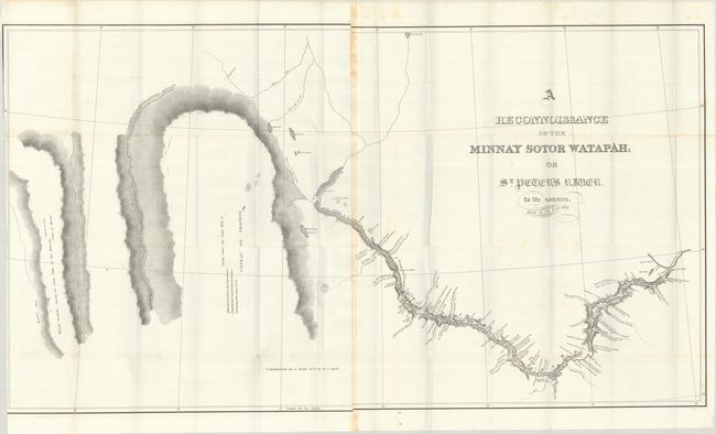
B. A Reconnoissance of the Minnay Sotor Watapah; or St. Peter's River. To Its Sources (41.7 x 22.9"). A large detailed map of the course of the Minnesota River from Fort Snelling and the Falls of St. Anthony (Minneapolis) northwest to Big Stone Lake. Locates numerous Indian villages along the river's course, numerous tributaries, and notations concerning the land and soil types. On a detailed scale of 8 miles per inch. Two sheets joined and folding, as issued.
References: Claussen & Friis #94 & #95.
Condition: B+
Issued folding on bright sheets with some light scattered foxing and a bit of toning along the joints. The first map has a small stain in Lake Michigan and is trimmed to the right border by the binder. The second map is trimmed to just inside the left border also by the binder.