Subject: Exploration & Surveys
Period: 1860 (published)
Publication:
Color: Black & White
Size:
6 x 9.1 inches
15.2 x 23.1 cm
This GLO report is scarcer than most years and contains 9 maps showing the status of surveying including:
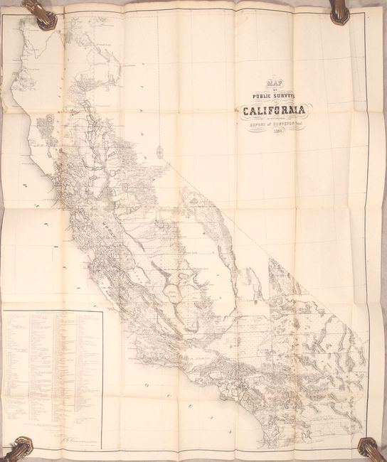
A. Map of Public Surveys in California to Accompany Report of Surveyor Genl... (29.8 x 35.9"). This large and detailed map delineates the progress of public surveys throughout the state. About one-quarter of the state remains unsurveyed mostly in the northern coast range and the Sierra Nevadas. A large inset lists 340 "Private Grants finally surveyed" plus three Indian Reservations (Nome Lackee, Nome Cult, and Sebastian).
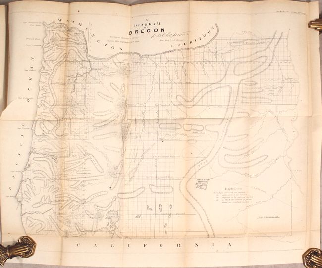
B. A Diagram of Oregon (23.0 x 17.6"). A detailed map created at the land office in Eugene City. It shows topographical information in hachure, watersheds, and the progress of surveying. Eugene City, Oregon City, and Salem are named. Trails and roads shown include the Old Immigrant Road, Northern Immigrant Road, "New Road," Trail to Powder River, Lt. Scholl's Route, and more. Across the Snake River is Fort Boise.
C. Map Showing the Progress of the Public Surveys in the Territories of Kansas and Nebraska... (18.4 x 24.4").
D. Sketch of the Public Surveys in the State of Minnesota (19.9 x 22.4").
E. Map of the State of Florida Showing the Progress of the Surveys... (24.6 x 23.3").
F. Map of Louisiana Representing the Several Land Districts (16.4 x 15.6").
G. Sketch of the Public Surveys in the State of Wisconsin and Territory of Minnesota (22.4 x 18.4").
H. Sketch of the Public Surveys in Iowa and Dakota (21.0 x 17.1").
I. Map of a Part of Washington Territory to Accompany the Report of the Surveyor General (27.8 x 21.8").
Hardbound in brown blind-stamped cloth featuring the U.S. seal on both covers and gilt title on the spine.
References:
Condition: B+
Maps are in better condition than most on clean bright sheets with occasional fold separations and edge tears. The map of California is loose. Accompanying text is mostly clean and bright but lacks the title page. Covers have light wear and the spine is sunned.