Catalog Archive
Auction 184, Lot 734

Pictorial Route Map of Ill-fated First Solo Transpacific Flight

"[Untitled - Pictorial Route Map of Ill-Fated First Solo Transpacific Flight]",

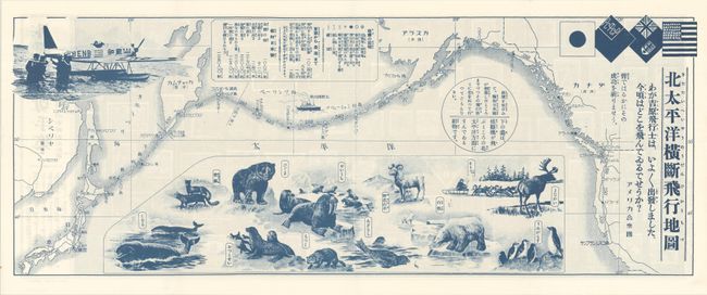
Subject: North Pacific Ocean

Period: 1931 (circa)

Publication:

Color: Printed Color

Size:
24.1 x 9.3 inches
61.2 x 23.6 cm
Download High Resolution Image
(or just click on image to launch the Zoom viewer)

This pictorial route map depicts Seija Yoshihara's (the “Lindbergh of Japan") extremely ambitious solo crossing of the Pacific to San Francisco via the Aleutian Islands and British Columbia. Yoshihara had already made a Berlin to Tokyo flight in a tiny, open cockpit Junkers A50 plane. On this journey, however, bad weather forced his plane to ditch into the Pacific near the Kurile Islands. He was rescued but the plane was damaged beyond repair. The map shows in nice detail the proposed route around the Pacific. The Junkers A50 plane is illustrated in the upper left corner. Flags of the nations he was to fly over are in the upper right corner. In the vast Pacific are illustrations of various sea and land creatures. The verso consists entirely of illustrations of postage stamps from around the world. For a brief article on the flight, click here.

References:

Condition: A+

Issued folding.

Estimate: $160 - $190

Sold for: $180

Closed on 9/15/2021

Archived