Subject: Eastern Africa
Period: 1597 (circa)
Publication: Petits Voyages, Part I
Color: Black & White
Size:
15.8 x 21.4 inches
40.1 x 54.4 cm
This copper engraving is from a remarkable series of publications, illustrating voyages of discovery and travels of exploration to various parts of the world. The project was begun by Theodore de Bry of Frankfurt, in 1590 and was to continue for another 54 years. They became known collectively as the Grands Voyages (to America and the West Indies) and the Petits Voyages (to the Orient and the East Indies). De Bry died after the first six parts of the Grands Voyages were completed. The project was completed initially by his widow and two sons, Johann Theodore de Bry and Johann Israel de Bry, then by Johann Theodore's son-in-law, Matthaus Merian, in 1624.
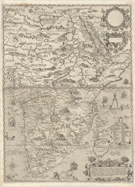
This rare two-sheet map is De Bry's edition of Filippo Pigafetta's important map that was significant in the mapping of the African continent. The map covers the eastern part of the continent and takes a major deviation from the long-held Ptolemaic beliefs concerning the source of the Nile. In this depiction, the Ptolemaic side-by-side lakes in the Mountains of the Moon are replaced by two large lakes in central Africa. The lakes are on a north-south axis with the northern one being the source of the Nile. These lakes, connected by a river, form the source of virtually the entire continental river system, spawning rivers that flow into the Atlantic and Indian oceans and the Mediterranean Sea. A cartouche covering part of Madagascar includes an extensive key. The map is beautifully engraved with a stippled sea that is filled with sailing ships and fantastic sea monsters. Three additional strapwork cartouches, two of which are blank, complete the composition.
Pigafetta's map was an important source on central Africa and the Congo for subsequent mapmakers. The map was the result of the travels of the Portuguese explorer, Duarte Lopes, who journeyed through the Kingdom of the Congo from 1578 to 1587. On his return to Europe, he went to Rome to make a report to Pope Sixtus V and met Filippo Pigafetta who compiled the information and published Relatione del reame di Congo in 1591. The work was immediately popular and translations soon appeared in Dutch, English, Latin, and German. This is from Part I of De Bry's Petits Voyages. Printed on two sheets and professionally joined.
References: Garratt (TMC-9) pp. 9-10; cf. Norwich #16.
Condition: B+
Issued folding, now flattened on bright, watermarked sheets with very light soiling and some minor extraneous creasing. Trimmed just within the map border at top left and bottom right. There are a few tiny separations along the folds and short edge tears that have been archivally repaired.