Subject: New York City, New York
Period: 1855-76 (dated)
Publication:
Color:
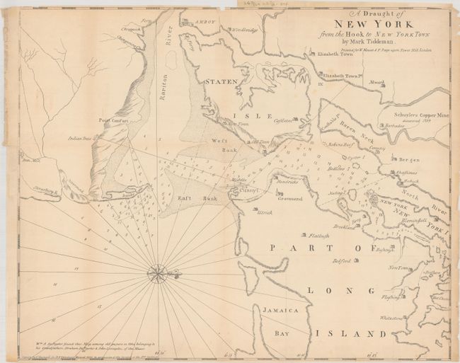
A. [Facsimile] A Draught of New York from the Hook to New York Town by Mark Tiddeman, by George Hayward, from D.T. Valentine's Manual, dated 1855, black & white (20.8 x 16.9"). This interesting map reproduces the so-called Tiddeman Chart of New York City and the harbor. Originally published in 1732 in the fourth book of The English Pilot, the chart appeared in multiple editions until 1780 with no substantial corrections. It spans from Sandy Hook to upper Manhattan and names Amboy, Newark, Brookland (Brooklyn), Flatbush, Bushwyck (Bushwick), Hobuck (Hoboken), Flushing, Westchester, and more. Schuylers Copper Mine is noted near Newark Bay. Although the chart was a cut above other contemporary charts, the Tiddeman Chart is still riddled with inaccuracies that likely mislead many navigators. The waters are filled with soundings and a compass rose orients the north to the right. This copy was performed by George Hayward and published in Valentine's Manual. Reference: cf. Augustyn & Cohen (Manhattan) pp. 66-68; cf. Seller & Van Ee #1220. Condition: Issued folding with light toning and numerous fold separations, edge tears, and a binding tear that have been closed on verso with tape. The top and bottom margins are trimmed close to the neatline in a couple areas and a binding trim at left has been replaced with old paper. (B)
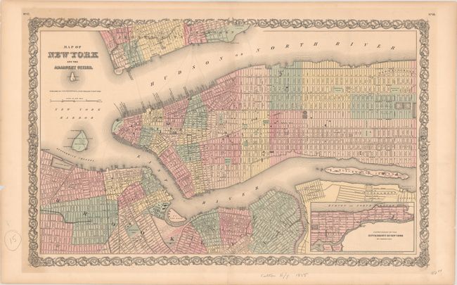
B. Map of New York and the Adjacent Cities, by Joseph Hutchins Colton, dated 1855, hand color (26.3 x 16.2"). Great double-page map of Manhattan up to 87th Street including parts of Brooklyn, Jersey City, and Hoboken and an inset that extends to show Harlem. There is fine detail of streets, squares, the Battery, and parks including the proposed Central Park. The pre-Central Park area still shows the existing city streets, but with light lettering "Proposed Central Park". Out of 33 plans submitted anonymously, the city commissioners chose the "Greensward Plan" by Frederick Law Olmsted. Olmsted's plan was significantly influenced by his study of England's Birkenhead Park, which opened in 1847 and was the first publicly funded park in Britain. Inset extends from 86th Street up to King's Bridge on a reduced scale. Filled with fascinating detail. A handsome sheet with Colton's decorative border. Condition: Lightly toned with edge tears confined to the margins. (B+)
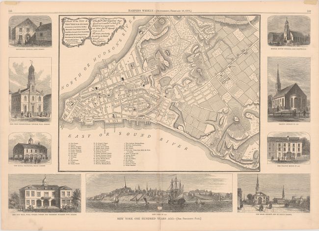
C. A Plan of the City of New York & Its Environs to Greenwich, on the North or Hudsons River, and to Crown Point, on the East or Sound River..., by Russell & Struthers, from Harper's Weekly, published 1876, black & white (20.8 x 13.9"). This fascinating sheet centers on a map based on the important Revolutionary Era Montresor plan of Manhattan, first published in 1767. Based on a survey conducted in secret, the original map featured many omissions and inaccuracies, but it also identified numerous streets, wharves, buildings, fields, gardens, orchards, farms, the names of some residents, industries, and windmills. A key at bottom left identifies 39 sites of interest, and at top left are title and dedication cartouches that hearken back to the Montresor original. The map is surrounded by nine elegantly engraved views depicting the city as it was in 1776. An essay on verso describes "New York One Hundred Years Ago." Condition: There is minor toning, a small abrasion, and a few short tears around the centerfold, including one separation that has been closed on verso with paper tape. Remnants of hinge tape on recto. (B+)
References:
Condition:
See description above.