Catalog Archive
Auction 184, Lot 259

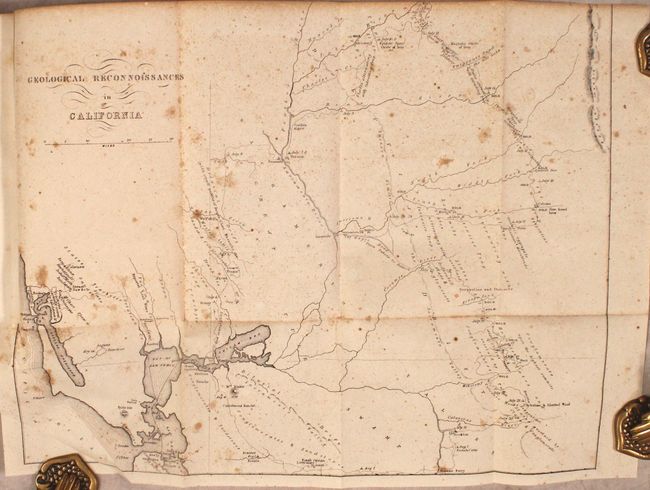
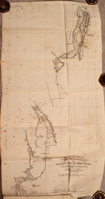
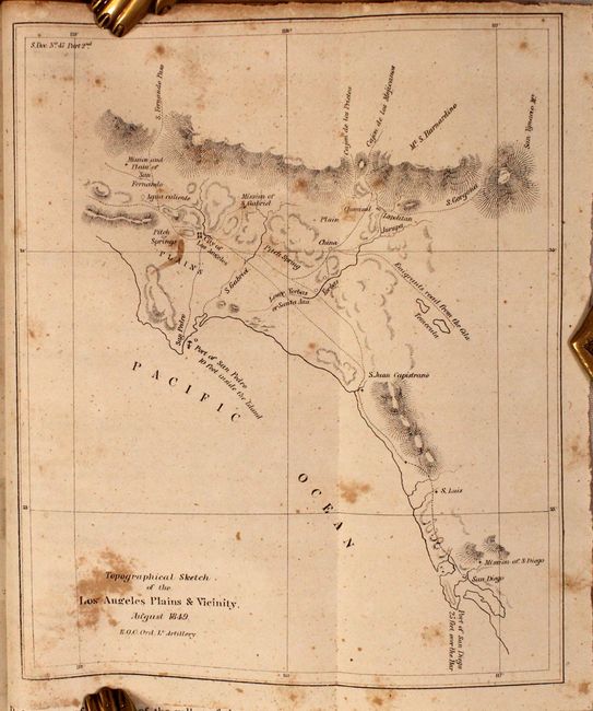
Gold Rush Maps and the First "Official" Map of Los Angeles

"[Maps in Report] [Gold Rush Maps] [and] Topographical Sketch of Los Angeles Plains & Vicinity [in] Report of the Secretary of War, Communicating Information in Relation to the Geology and Topography in California", U.S. War Department

Subject: California Gold Rush, Los Angeles

Period: 1850 (published)

Publication: Sen. Ex. Doc. 47, 31st Congress, 1st Session

Color: Black & White

Size:
5.8 x 8.8 inches
14.7 x 22.4 cm
Download High Resolution Image
(or just click on image to launch the Zoom viewer)

This is Philip Tyson's report concerning the geology and topography of the area between San Francisco and the Gold Region and is notable for the inclusion of the first geological maps and sketches of the region. Of particular interest is the Geological Reconnoissances in California (14.8 x 11.7") which shows the area from San Francisco Bay north and east to the Yuba River and east to the Calaveras River. The map traces his route from San Francisco by way of Vernon to the Yuba diggings, then south passed the Emigrant's Road to the Salt Lake, through the gold region to the Calaveras River, and west through Bonsal's Ferry, Livernore’s Ranch and Martinez. It notes dates of his encampments, geological formations and the points where gold was being mined. According to Wheat, Tyson's work was "probably the earliest work of a true scientific research to emerge from the Gold Rush." Also included in Tyson's report is Sketch of the Route of Capt. Warner's Exploring Party in the Sacramento Valley and Sierra Nevada... (11.1 x 23.5") and The Sacramento Valley from the American River to Butte Creek... (17.5 x 21.8"). This latter map provides a detailed view of the region with numerous small towns, ranches, Diggings (including Mormon and Dry), trails and roads. Interesting notations concern grazing, road conditions and soil fertility. This early look at the Gold Regions locates Sacramento City just south of the American River (as a simple grid pattern), Vernon, Fremont, Sutter and Green Spring.

This report also includes E.O.C. Ord's Topographical Sketch of Los Angeles Plains & Vicinity (6.1 x 7.4") and Survey of Public Lands in the Gold Region (8.6 x 7.9"). The Ruderman Map Collection at Stanford describes the Los Angeles sketch as “a curious addition to a publication whose real subject matter was the discovery of Gold in California. Nevertheless, it is of great significance as the first map done by Ord and also the first 'official' map of Los Angeles" (click here for more details.) Because military salaries could not keep up with Gold Region price inflation, Ord was authorized to work for local officials and produce the first formal survey of nascent Los Angeles.

Disbound, 164 total pages with 13 folding maps and plates.

References: Howes #T-455; Wheat (Gold) #149 & #179.

Condition: B

Folding maps are moderately foxed. Disbound text is mostly clean with some scattered foxing.

Estimate: $400 - $475

Sold for: $950

Closed on 9/15/2021

Archived