Subject: Central United States
Period: 1853-54 (dated)
Publication: U.S. Pacific Railroad Surveys
Color: Black & White
Size:
80.3 x 26.4 inches
204 x 67.1 cm
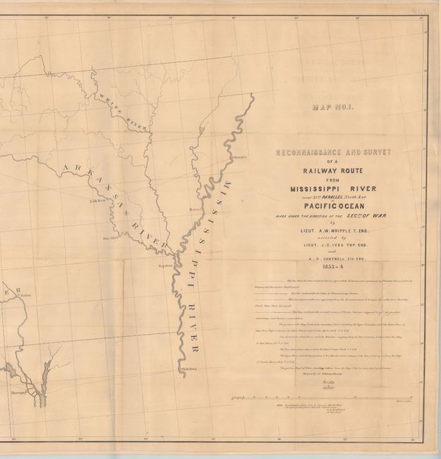
During the 1850s, the U.S. government sponsored an extensive series of expeditions designed to gather information on the vast new territories that had been acquired in western North America. The discovery of gold in California further stimulated westward traffic and heightened the need for a faster and more convenient way to bring the far-flung parts of the country together. In 1853 Congress commissioned the Army's Topographic Bureau to conduct a series of surveys to find a suitable route for a transcontinental railroad. There were six major expeditions; five of them covered the area between the Great Plains and west coast, and the sixth explored the coastal states of California and Oregon. All of these expeditions were accompanied by naturalists and artists to document the landscape, flora and fauna along the route.
The reports, maps and lithographs were published in the 13 volume report "Explorations and Surveys to ascertain the most practicable and economical route for a Railroad from the Mississippi river to the Pacific Ocean."
This mammoth map is the result of the explorations and surveys of Lieut. A.W. Whipple and Lieut. J.C. Ives, Topographical Engineers, and A.H. Campbell, Civil Engineer that was issued as part of a two-map set. Wheat says Whipple "had demonstrated that the route which he had surveyed was practicable for a railroad, and the Santa Fe Railroad now traverses much of it … This is an important map, in its two parts, and reflects great credit upon Whipple and his entire party." This map extends from the vicinity of Memphis and Vicksburg to the Rio Grande valley at Santa Fe and Albuquerque. Locates forts Arbuckle, Washita, Smith and numerous Indian villages. The second map (not present) continues on to Los Angeles. Drawn by A. Schimmelfinnig. An uncommon map that has been stabilized with linen and encased in Mylar for preservation.
References: Wheat (TMW) #872.
Condition: B
Issued folding and now flattened and backed with linen to reinforce and repair numerous small splits at the junctions with some minor loss. There are 7" and 5" separations at right that are no longer glued down to the linen. Light toning and offsetting.