Catalog Archive
Auction 184, Lot 205

"[Reproduction] Virginia and Maryland as It Is Planted and Inhabited This Present Year 1670 Surveyed and Exactly Drawne by the Only Labour & Endeavour of Augustin Hermann Bohemiensis",

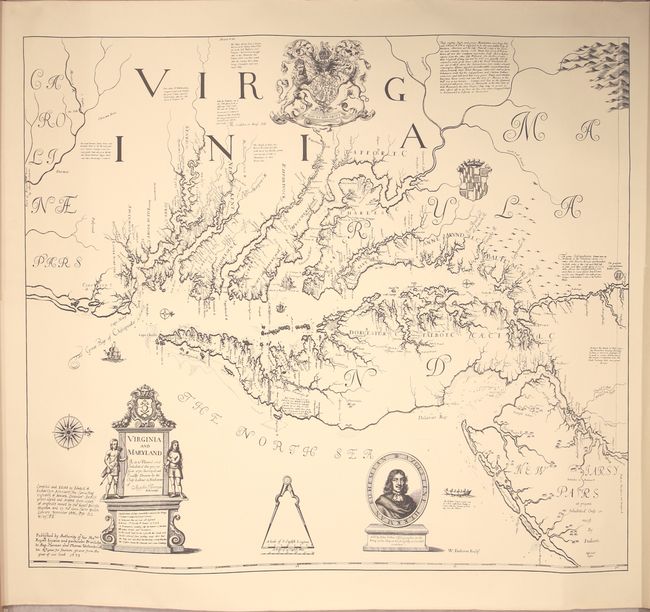
Subject: Mid-Atlantic United States

Period: 1970 (dated)

Publication:

Color: Black & White

Size:
36.6 x 31 inches
93 x 78.7 cm
Download High Resolution Image
(or just click on image to launch the Zoom viewer)

This is a full-size reproduction of Augustine Herman's landmark map of Virginia and Maryland. When first published in 1673, this map was the most accurate map of the region since John Smith's map of 1612, and was not superseded until Joshua Fry and Peter Jefferson's map of Virginia around 1753. Only a handful of original examples of Herman's map are known to exist. Although Herman's map was originally published on four sheets, this reproduction is printed on one single sheet. The image was compiled and edited by Edward H. Richardson Associates, Inc. from "copies of the originals owned by the British Museum and by the John Carter Brown Library." The map is accompanied by a sheet describing a bit of the history of Augustine Herman and his map.

References: Burden #429.

Condition: A

A few minor edge creases.

Estimate: $240 - $300

Sold for: $180

Closed on 9/15/2021

Archived