Subject: Western Africa
Period: 1750-65 (dated)
Publication:
Color: Black & White
Size:
21.3 x 34.5 inches
54.1 x 87.6 cm
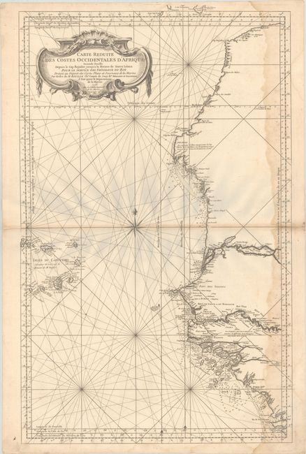
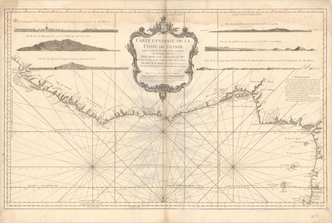
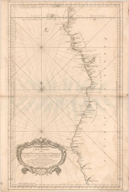
This matching set of three maps illustrates the western coastline of Africa from Morocco to XXX. Jacques Nicolas Bellin began working for the Depot des Cartes et Plans de la Marine at age eighteen and remained there for his entire life, becoming Ingenieur-Hydrograph in 1741. Though he never traveled himself, he gathered an incredible amount of cartographic information from various sources and compiled it to produce some of the most important French maps, particularly sea charts, of the 18th century. Each sheet stands on its own with an elaborate rococo cartouche and full borders. Size varies slightly.
A. Carte Reduite des Costes Occidentales d'Afrique Seconde Feuille Depuis le Cap Bojador Jusqu'a la Riviere de Sierra Leona, dated 1765. This large nautical chart of the West African coast, from Sierra Leone to southern Morocco, includes the Cape Verde Islands and part of the Canaries, all on a scale of about 1:3,000,000. A tremendous amount of information is presented along the coastline with soundings, safe anchorages, rocks and shoals. The major rivers are also shown in detail with villages, forts and notations. The chart was originally drawn in 1753; this example is updated to 1765.
B. Carte Generale de la Coste de Guinee Depuis la Riviere de Sierra Leona Jusqu'au Cap de Lopes Gonsalvo, dated 1750. This striking sea chart continues the western coast from Sierra Leone to Cape Lopez. Six coastal views and a huge decorative title cartouche fill the interior. The chart is engraved with minute detail including anchorages, navigational hazards, soundings, forts, settlements, and watering places.
C. Carte Reduite des Costes Occidentales d'Afrique Depuis l'Equateur Jusqu'au Vingtieme Degre de Latitude Meridionale Comprenant les Isles de St. Thome et du Prince les Costes d'Angole, dated 1754. This large, striking sea chart of the southwestern coast of Africa covers the coast from the equator to 20° S latitude; Gabon (with Sao Tome and Principe) to Namibia. It provides a wealth of information including anchorages, forts, villages, and navigational hazards. The Skeleton Coast is marked as unknown (Coste n'est pas connue). The handsome chart features rhumb lines, a decorative compass rose, and an exquisite title cartouche.
References:
Condition: B
Nice impressions on sturdy sheets with large double-headed eagle watermarks, light toning along the centerfolds, minor soiling, and large dampstains along one long edge of the sheet.