Subject: Scotland
Period: 1653 (dated)
Publication: Atlas Nuevo de los Reynos de Escosia e Yrlanda
Color: Hand Color
Size:
21.4 x 16.5 inches
54.4 x 41.9 cm
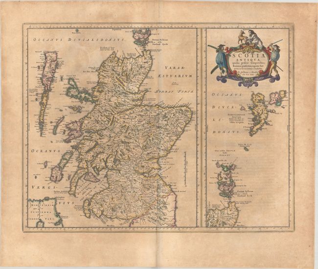
This handsome map of ancient Scotland is based on the work of Robert Gordon of Straloch (1580-1661), a polymath with an interest in Scottish history and geography who stepped in to supplement and continue the unfinished work of Timothy Pont at Charles I's behest. Gordon also contributed to Blaeu's atlas several topographical descriptions and introductory passages on Scottish history. The map features fine topographical detail and plenty of ancient place names. A large inset at right continues coverage to the Orkney and Shetland Islands. There is an ornate title cartouche at top right surrounded by allegorical figures. Spanish text on verso, published between 1657-62.
Publication of Bleau’s atlas of Scotland and Ireland (Atlas Novus, Volume V) in 1654 was a landmark publication in cartographic history. Most of the maps were based on the surveys of Timothy Pont, which had been done half a century earlier. The publication took over seven decades to bring to publication; it was delayed by wars, copyright restrictions, and only intermittent official support. The maps are scarce today due to the relatively short publication history of the atlas.
References: Van der Krogt (Vol. II) #5800H:2.
Condition: B
A nice impression with contemporary color on a moderately toned sheet with a large Atlas watermark and some minor creasing along the centerfold.