Subject: Bermuda
Period: 1947 (dated)
Publication:
Color: Printed Color
Size:
26.7 x 21 inches
67.8 x 53.3 cm
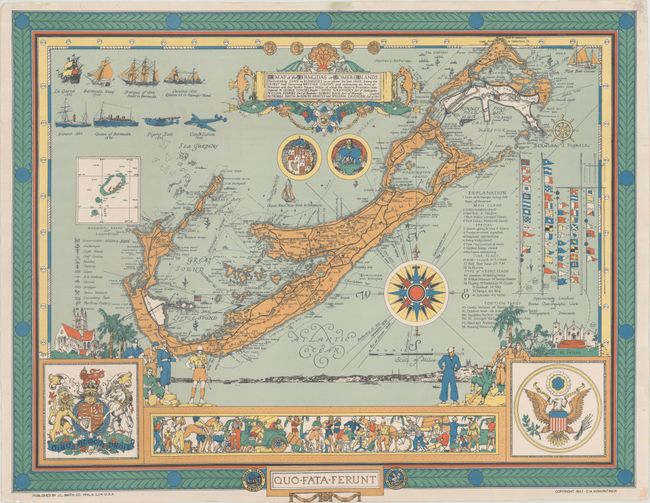
This elegant and informative souvenir map of Bermuda was created by D. M. Kirkpartick and is updated from a slightly larger edition initially published in 1934. The title gives a very brief explanation of the European discovery and colonization of the island with the coats of arms of Bermuda just below. The map includes a key identifying everything a tourist may need to know: military sites, anchorages, light houses, golf clubs, beaches, taverns, caves, tennis stadiums, swimming pools, hotels, and a perfume factory. At right is a key showing numerous flags with explanations of their meaning, and at top are coins and ships important to the history of Bermuda. The important updates to this 1947 edition relate to the 99-year lease granted to the United States by Winston Churchill in 1941 allowing the U.S. to constructs a military base and airfield on Bermuda, which is shown in white encompassing all of St. David's Island. The seal of the United States has also been added to the map, balancing the seal of Great Britain. And of course the flying boat (1940) and the Lockheed Constellation airliner (1946) have been added adjacent to the images of important ships. A colorful frieze featuring the people and activities of Bermuda has also been added to this later edition. Published by J.L. Smith Co.
Donald Morris Kirkpatrick (1887-1966) was a notable American architect, professor and artist. Born and raised in Pennsylvania, Kirkpatrick studied architecture and began a career in this field, earning numerous awards and accolades. After vacationing in Bermuda for his honeymoon and several other trips, Kirkpatrick and his wife moved to Bermuda in 1934. While he continued his work as an architect, he also branched out into art, creating numerous watercolors, many of which now reside in museums and art institutes. This map is one of two souvenir pictorial maps of Bermuda made by Kirkpatrick, with the first version published in 1934.
References: Rumsey #9390.
Condition: A
A clean and bright example that has been professionally backed in archival tissue, repairing a few tiny tears and chips along the edges of the sheet.


