Catalog Archive
Auction 183, Lot 226

NO RESERVE

"Ohio Boundary. No. III South Bend of Lake Erie: Map Exhibiting the Position Occupied in the Determination of the Most Southwardly Point of the Boundary Line Between the United States & Canada...", Hood, Washington (Lt.)

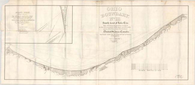
Subject: Northern Ohio, Lake Erie

Period: 1835 (dated)

Publication:

Color: Black & White

Size:
45.4 x 18.6 inches
115.3 x 47.2 cm
Download High Resolution Image
(or just click on image to launch the Zoom viewer)

This map from the U.S. Corps of Engineers details the southern coast of Lake Erie from the beacon at Huron to School House Point. There is nice topographical detail along the coast. An inset map at top left shows Point Pele, "the second position occupied in the determination of the most southwardly point of the boundary between the United States & Canada." Surveyed by Lieutenants Washington Hood and Robert E. Lee under the supervision of Captain Andrew Talcott. This map was one of a series related to the boundary dispute between Michigan and Ohio wherein Ohio refused to allow Michigan's statehood admission until the matter was resolved in Ohio's favor.

References: Claussen & Friis #112; Karpinsky #685.

Condition: B+

Issued folding with light offsetting, minor scattered foxing, and a couple short tears in the inset.

Estimate: $120 - $150

Sold for: $37

Closed on 6/9/2021

Archived