Subject: Hawaii
Period: 1784 (circa)
Publication:
Color: Black & White
Size:
17.7 x 11.3 inches
45 x 28.7 cm
Captain James Cook (1728-1779) is best known for his three voyages to the Pacific (1768-71; 1772-75; and 1776-79). His discoveries radically changed the western understanding of the world in the late 18th century. He was the first to circumnavigate and chart New Zealand and provided the earliest European accounts of exploration along the eastern coast of Australia and the Hawaiian Islands. On February 14th, 1779, he was killed on Hawaii after attempting to kidnap the chief of the island.
Many contemporary accounts of Cook’s voyages, including charts and engravings, appeared in the late 18th century. The first official account of Cook’s first voyage was published in 1773 by John Hawkesworth in Volumes II and III of An Account of the Voyages Undertaken by the Order of His Present Majesty for Making Discoveries in the Southern Hemisphere... William Strahan and Thomas Cadell published the first official accounts of the second and third voyages in 1777 and 1784. Accounts of his exploration were subsequently translated into French, German, and Dutch.
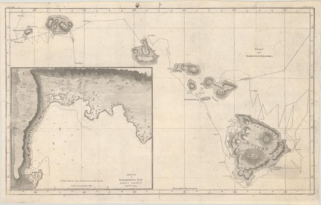
This is the uncommon Dublin edition of this landmark in Hawaiian cartography, engraved by J. Butler and published in a pirated edition of the third volume of Cook's voyages by the United Company of Booksellers. Although the first printed map of Hawaii is credited to Captain James Cook, it was prepared for publication by Lieutenant Henry Roberts, who prepared all of the maps for the three-volume narrative of Cook's final voyage. Roberts drew the map from a now-missing survey by William Bligh (of Mutiny on the Bounty fame) who was Sailing Master on the HMS Resolution. The map provided the basis for all subsequent mapping of the islands. The routes of the Resolution and the Discovery around the islands are carefully traced with nice topographical detail on each island. A large inset of Karakakooa Bay (Kealakekua Bay) is featured with details of soundings, navigational hazards and the anchorages of the two ships, and quaint depictions of houses, palm trees, and fields inland. Cook spent his last few weeks in Kealakekua Bay before dying in a confrontation with natives on February 14, 1779.
References: cf. Fitzpatrick, pp. 15-18, plt. 2.
Condition: A
Issued folding, now flat, with light printer's ink residue, a printer's crease at bottom left, and an archivally repaired binding tear that just touches the neatline at right.