Subject: Central United States, Michigan Territory
Period: 1823 (circa)
Publication: A General Atlas
Color: Hand Color
Size:
12.1 x 9 inches
30.7 x 22.9 cm
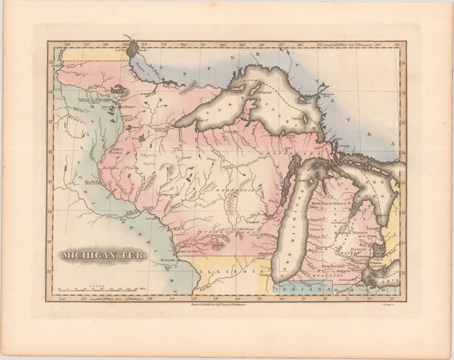
This scarce map is the earliest printed map to show the full extent of Michigan Territory as it existed from 1818 to 1833. After Indiana and Illinois were admitted into the Union in 1816 and 1818, remaining portions of their territories were incorporated into Michigan Territory. Very few atlas maps devote maps specifically to the territory, and the contemporaneous Carey & Lea map only shows the pre-1818 configuration. On this map, the territory includes present-day Wisconsin and part of Minnesota. It is bounded on the west by the Mississippi and Red River of the North. Detroit is depicted as the capital, and forts, portages, mines, and Indian villages are located. There is nice detail of the territory's lakes and rivers. Buffaloe Plains, fur trading posts, and the sources of the Mississippi are noted as well. Chicago is named on the coast of Lake Michigan. Engraved by B.T. Welch.
Fielding Lucas produced some of the finest American maps of the era, which were exquisitely engraved, printed on high quality paper, and attractively hand colored.
References: Karpinski #92; Phillips (Atlases) #742-75.
Condition: A
A crisp impression with contemporary color and a few faint spots in the margins.