Subject: Western Hemisphere - America
Period: 1787 (dated)
Publication:
Color: Hand Color
Size:
28.7 x 20.4 inches
72.9 x 51.8 cm
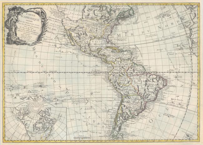
The era of exploration is dramatically shown on this rare map with the tracts of explorers shown, including Magellan, Mendana, Quiros, Le Maire, Bougainville, Furneaux, and Cook. It was first issued by Jean Baptiste Louis Clouet in 1761 with a slightly different title (Carte d'Amerique Divisee en ses Principaux Pays Dressee sur les Memoires les Plus Recents, et sur Differents Voyages). In this edition the plate has been revised to eliminate the erroneous Sea of the West, now shown as Pais Inconnu, and the inset has been updated to reveal the discoveries of Captain Cook in the Pacific Northwest and Alaska. In North America, the young United States is shown to include Florida, with a huge Louisiana Territory in the west. The names Cenis, Tecas, and Sta Fe appear in Noveau Mexique. Teguas and Quivira are identified in the west, and the region around present-day California is labeled Nl. Albion. In South America a large Paraguay takes in Buenos Aires. The decorative title cartouche features a female personification of America riding a fierce alligator.
References:
Condition: B+
A nice impression on a sturdy sheet that has been professionally remargined on all sides with the neatline replaced in facsimile. A chip at bottom left has also been professionally repaired with a portion of the border replaced in facsimile. There are a few small chips and tears that have been archivally repaired, and some tiny wormholes that are only visible when held up to light.