Subject: North Pacific Ocean, World War II
Period: 1944 (dated)
Publication:
Color: Printed Color
Size:
57.2 x 38.2 inches
145.3 x 97 cm
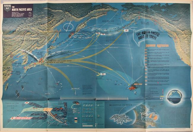
This very large pictorial map was produced by the Educational Services Section of the U.S. Navy. One of the division's primary goals was to inform American service members of the status of the war and to provide context for the battles they would be joining. This map is densely filled with illustrations and text describing the events in the North Pacific. Japanese invasion routes are shown in yellow with text stating "The Japanese Struck Boldly at Every Strategic Naval Base in the North Pacific." A United States counterattack is shown along the "North Pacific Road to Tokyo," after the U.S. defeated the Japanese at Attu (Aleutian Islands) in 1943. Insets at bottom include comprehensive accounts of the Battle of Midway and Battle of Attu. Detailed topography is represented with an interesting three-dimensional effect. A vivid depiction of the events in the Pacific theater of war.
References:
Condition: B+
Vivid color on a clean sheet. There are short separations mostly at the fold junctions with minor loss of image and a few small holes in the bottom corners of the sheet. Stamped "War Orientation Office" at bottom center.