Subject: Southwestern United States & Mexico
Period: 1851-57 (circa)
Publication:
Color: Black & White
After the Treaty of Guadeloupe Hidalgo ended the war with Mexico in 1848, it was necessary to establish a boundary acceptable to both parties. The Mexican Boundary Survey was the result.
A. Mexican Boundary B. Extract from the Treaty Map of Disturnell of 1847…, by James Duncan Graham, from 32nd Cong., 1st Sess., Senate Ex. Doc. 121, dated 1851 (15.4 x 8.9"). The process of surveying the US-Mexican Boundary was beset by politics, interdepartmental rivalries, and personal conflicts throughout the entire process. Ultimately, the dispute between the principals (mainly James Bartlett and James Duncan Graham) made its way to the floor of Congress and the claims and counterclaims ended up in numerous government documents.
This map was created by Graham to illustrate the boundary differences that resulted in a disputed 5,950 square mile region that was strategic to mining and railroads. It depicts a large shaded region in dispute as a result of a major error in the Disturnell map referenced in the Treaty of Guadalupe Hidalgo. The error was discovered when the American commissioner (John Russell Bartlett) and Mexican commissioner (General Pedro Garcia Conde) began the actual survey work for the southern boundary. Specifically, they discovered that Disturnell's map put the Rio Grande two degrees too far to the west and El Paso was placed about 30 miles too far north. The resulting 5,950 square mile error became a political and economic issue for both sides. The land itself was rich in minerals and, for the United States, was the only practical route for a southern transcontinental railroad. The issue was eventually resolved by the inclusion of the disputed area in the Gadsden Purchase, whereby the United States took over this disputed territory (along with other lands) in exchange for a cash payment. References: Martin & Martin, plt #40; Wheat (TMW) #718. Condition: Issued folding with light toning, minor offsetting, and a short split that has been closed on verso with archival tape. (B+)
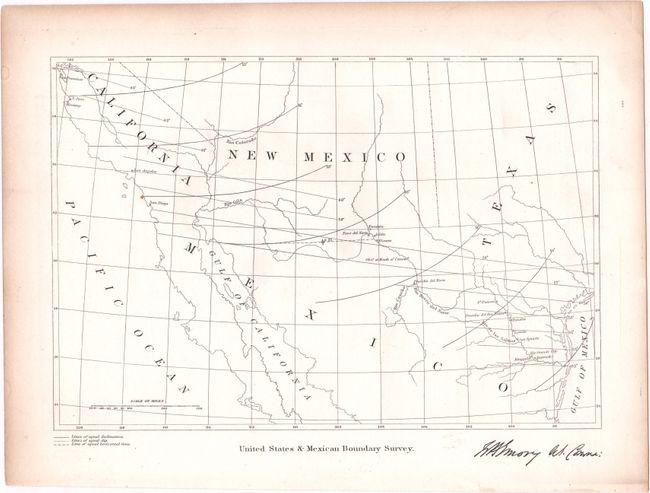
B. United States and Mexican Boundary Survey, by William Hemsley Emory, from Report on the United States and Mexican Boundary Survey, published 1857 (9.6 x 6.6"). Signed in the plate by Emory, this simple map shows the border region with lines of equal declination, equal dip, and equal horizontal force. Condition: A couple tiny spots and marginal toning, otherwise fine. (A)
References:
Condition:
See description above.