Subject: Southwestern United States
Period: 1855-60 (dated)
Publication:
Color: Black & White
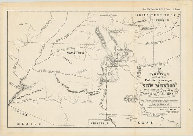
A. Sketch of Public Surveys in New Mexico to Accompany Report of Surveyor General, from Sen. Ex. Doc. No. 1, 34th Cong. 1st Sess., dated 1855 (10.9 x 7.3"). This is only the fourth map issued by the General Land Office. Wheat calls this a sketch but notes that it "is a beginning on the rough job of surveying the western states and territories." Surveys are confined along the Rio Grande between Taos and Santa Fe. Reference: Wheat [TMW] #854. Condition: Professionally backed with Japanese tissue with a binding trim in the left margin that has been replaced with old paper. (A)
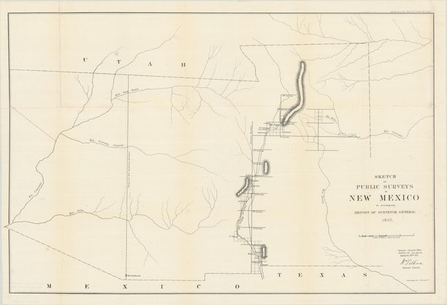
B. Sketch of Public Surveys in New Mexico to Accompany Report of Surveyor General, from Sen. Ex. Doc. No. 11 & Ho. Ex. No. 2 1st Sess. 35st Cong., dated 1857 (30.8 x 20.1"). Early, large-scale, territorial map by the Surveyor Generals Office, Santa Fe, New Mexico. Surveys now extend along the Rio Grande to the Mexican boundary. It includes all of today's Arizona and extends to include portions of eastern California and southern Utah to the north. The area of present-day New Mexico is depicted with limited surveying, primarily the settled areas of Santa Fe and along the valley of the Rio Grande River. Place names includes Meslia, Cruces, Ft. Filmore, Ft. Thorn, San Felipe, Algodones, Cochiti, and more. The region to the west of the Rio Grande is void of detail except for a few rivers and a proposed meridian at Fort Buchanan. Condition: Issued folding, now professionally backed with Japanese tissue to repair fold separations and tiny splits at intersections. There is faint scattered foxing and a small piece of superfluous Japanese tissue in map image on recto. (B+)
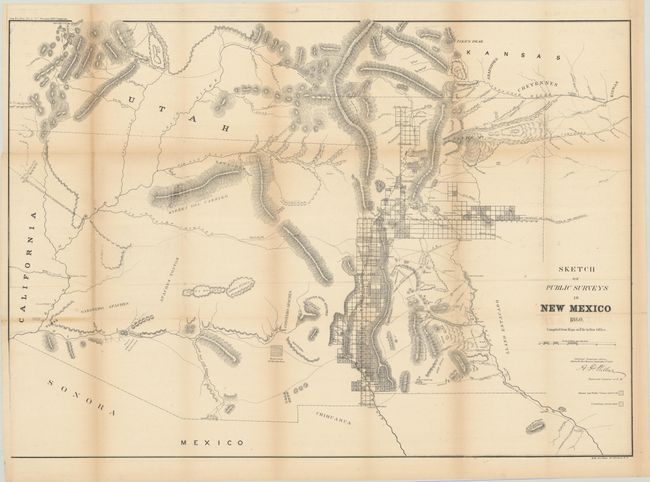
C. Sketch of Public Surveys in New Mexico, from Sen. Ex. Doc. No. 1 2nd Session 36th Congress, dated 1860 (32.5 x 22.9"). Signed in plate by Surveyor General A.P. Wilbar. The map depicts the territory prior to Colorado annexing the San Luis Valley region. It extends to the Colorado River and north to Salt Lake City. It locates numerous Indian villages and reservations, extent of surveys completed including Pueblo claims, and subdivided townships. Limited and mostly inaccurate detail is shown in present day Arizona. It traces the Santa Fe Trail (wagon road to Ft. Leavenworth) and the wagon road to San Antonio. Good detail of springs, watershed, mineral locations, and mountains in hachure. An early version of an increasingly difficult map to obtain. Condition: Issued folding, now professionally backed in Japanese tissue, repairing some short fold separations. There is light toning along the folds. (B+)
References:
Condition:
See description above.